Mt. Iwate (岩手山)
Last updated: Feb 6, 2025
Special note: Iwate is currently experiencing increased volcanic activity and is currently closed to hikers. Click here for more information.
Mt. Iwate is a conically shaped active volcano, towering over Morioka city and offers one of the best panoramic views in the entire Tohoku area.
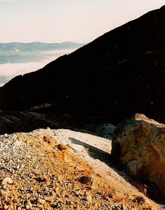
The hike: This is a long, long hike (about 21km round trip) so it’s imperative that you get an early start. Luckily there’s a incredible park near the trailhead at Kenmin no mori (県民の森). Officially camping is prohibited in the lush park but it’s much more inviting than the nearby campground, so just put up your tent behind the bushes or set up/break down at night. Anyway, the trailhead is NOT behind the park, so do not follow the dirt forest road toward Mt. Iwate or you’ll lose precious time like I did. Instead, walk down the hill a little to the right of the park (if facing the mountain) and walk up a paved road that leads to the trailhead. You should find it on your right-hand side after about 15 minutes or so. The maps in town are so confusing, so be careful. Anyway, this trail is called the nanataki course (七滝コース), and you’ll find the waterfall of the same name in about an hour. Now, this trail was officially closed to hikers in the summer of 2006 due to volcanic activity, but the trail is very clearly marked, so it looks like a lot of people ignore the signs and climb. After about 1-1/2 to 2 hours of hiking through the forest, the vegetation will start to thin out and you will find the first signs of volcanic activity. The ground will start to turn a lime green and you’ll notice a small, hot stream flowing down the mountain. Unfortunately the stream is too small to bath in, but you can soak your feet if you like. Follow this stream toward the right side and you’ll soon encounter steam vents puffing out volcanic gases. Make sure you stay on the trail and beware of loose rocks. Climbing is not much of a problem, but if you come back down this way be very careful on the decent. Anyway, as you climb higher, you’ll reach a junction where this trail meets the Matsukawa trail. You have two options. You can go right to take a ridge trail, or head left and follow a beautiful river. Take the left course and work your way toward the Mt. Iwate crater. The vegetation can be quite thick here, and if there’s any morning dew then you’ll get completely soaked from head to toe. After about 90 minutes of slogging, you’ll come to an emergency hut and a set of benches. This is at the base of the crater. Take a break and prepare yourself for the final ascent. If you’re running short of water then head down the trail away from the crater and there’s a second hut and water source there. The final climb is tough. You’ve just spent the last 4 or 5 hours climbing about 1400 vertical meters, and now the final 100m or so is on loose scree. For every step you take, you’ll lose about 2 or 3. Don’t give up yet though, because once you make it to the crater rim things become much easier. The high point is to your left, but consider walking all the way around the rim if the weather is good. The crater itself has stopped hissing and steaming, but the rock formations and gradation are wonderful. Take plenty of pictures and if you’re lucky, take in the panorama. On a clear day you can see Mt. Hayachine, Mt. Chokai, Gassan, Mt. Hachimantai, and Mt. Akita Koma ga Take. If you’re feeling exhausted, then you have two free emergency huts to choose from, as well as two alternate ways off the mountain. I went back exactly the way I came, because I left my huge backpack at the trailhead and carried only a small bum bag, water, and a camera on the hike.
When to go: This hike can be done from late April to early November, but the earlier you go, the more snow you’ll encounter. Because of the distance involved, summer is probably the best season because you’ll be blessed with plenty of daylight hours.
Access: There are only 2 trails accessible by public transport. If you’ve got a car, then you can consider approaching from the other, more popular side of the mountain. I hitchhiked from neighboring Mt. Hachimantai and ended up at Hachimantai Onsen (八幡平温泉郷). The Matsukawa trail from Matsukawa Onsen also looks promising. Both hot springs are accessible by bus from Morioka station. The most popular trail is called the Yakebashiri (焼走り) trail, reachable by taxi from Oobuke (大更) station near Morioka. Click here for the bus schedule to Matsukawa Onsen.
Map: Click here
Live web camera: Click here
Level of difficulty: 5 out of 5 (elevation change: ~1500m)
Explore posts in the same categories: ArchiveTags: hiking, Hyakumeizan (百名山), japan, Mt. Iwate, Tohoku hikes (東北)
You can comment below, or link to this permanent URL from your own site.
Leave a comment