Harima Alps (播磨アルプス)
The Harima Alps are a series of small rock formations on the border of Himeji and Kakogawa cities in Hyogo Prefecture. While not very Alpine in nature, the hike does feature some really nice species of native pine trees, wild boar, desert-like vegetation, and not a single cedar tree!
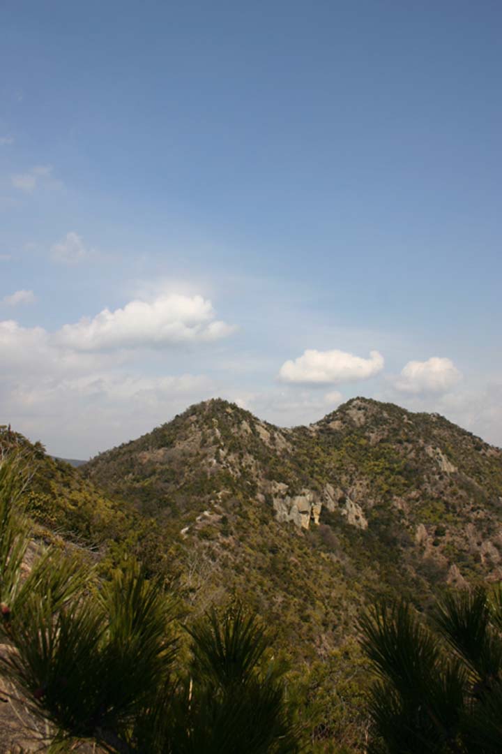
The hike: Head through the ticket gate at Sone station and turn right. Follow the road to the next intersection and turn left. Walk a few blocks, passing a small lake on the right, and you’ll come to a rather busy road. This is called Highway 2. Turn right and walk along highway 2 for about 1km or so. You’ll pass a couple of convenience stores on the right-hand side, so stock up on supplies (there’s no water on the hike). The mountains on your left side are the “Alps” and that’s what you’ll be traversing for the next 5 hours or so. Keep walking along highway 2 until coming to a small shrine on the left-hand side. The trail is directly behind this shrine. The path climbs steeply through a dense forest. Be on the lookout for wild boar in this area. A golf driving range will come into view on your right. Keep climbing up to the ridge line. You’ll know you hit the ridge when you find a gigantic electric tower standing right in the middle of the trail. This is a good place for a short break. The path continues straight ahead (ignore both of the trails branching off to the left and right). Basically, you’ll want to follow the contours of the ridge and the signs to Mt. Takamikura (高御位山). It should take an hour or so to reach the shrine and splendid rock formations here. If it’s a clear day without too much smog, you’ll be able to see Kobe & Osaka cities, Akashi Bridge, Himeji, Osaka bay, Awaji Island, and the peaks of northern Hyogo Pref. If you look straight down you’ll see a lot of small lakes used to irrigate the surrounding fields. There are a ton of escape routes to choose from, but your main goal should be to make it back to Sone station by traversing all of the peaks between this mountain and the station! The next peak along the ridge is called Takanosu (鷹ノ巣山). Ignore all of the small trails branching off the ridge. As long as you follow the signs you’ll be ok. Mt. Takanosu is actually 2 twin peaks, and both of them should be reached in about 45 min. or so. From here, the next target is an unnamed peak with a large microwave antenna on top (it looks like a billboard). Between here and the unnamed peak, you’ll probably hear some gunfire down in the valley. If you look down over the right side of the ridge, you’ll see a very large shooting range! Anyway, head up to the antenna. There’s a very promising looking trail heading off to the right, but stay to the left and head down a very steep rock formation. At the bottom of this rock, you’ll find a concrete bunker and a vast network of trails branching off in all directions. You’ll also find a sign leading to Kashima Shrine (鹿嶋神社). Feel free to descend to the shrine to have a look around, but you’ll have to climb back up to the ridge to complete the traverse. Continue on the same ridge line, and climb the steep mountain in front of you. This peak is called Ootani (大谷山). Keep going to the next small peak, where you’ll find a huge cave in the middle of the trail! This is the site of an ancient burial mound currently under excavation. From this hole, continue going straight and you’ll drop off the mountain very steeply and end up back in civilization. When you hit a small road, turn left and you’ll be back at highway 2. Turn left on highway 2 and cross over the overhead pedestrian bridge. Turn right at the next big street. This is the same street you took to get to highway 2 at the start of the hike. Turn right at the next intersection and you’ll be back at Sone station. This hike can be done in reverse but the trailhead is very difficult to find!
When to go: This hike can be done year round, but there’s a lot of climbing and descending on steep rock formations, so avoid this hike in wet weather.
Access: From either Osaka, Kyoto, or Sannomiya stations, take the JR Shikaisoku (新快速) train bound for Himeji (姫路). Get off at Kakogawa station (加古川) and change to a local train bound for Himeji. The stop closest to the trailhead is called Sone (曽根駅).
Level of difficulty: 2 out of 5 (elevation change 200m)
Explore posts in the same categories: UncategorizedTags: Harima Alps, hiking, japan, Kakogawa, Kansai hikes (関西地方)
You can comment below, or link to this permanent URL from your own site.
May 8, 2011 at 10:54 pm
We completed this hike in 5 hours today. There were lots of little (and not so little) ups and downs and the views were stunning. The rock formations were fantastic to climb up and we almost always had 360 degree views of the mountains, valleys, and (manmade) lakes around us. Next time we’re going to start from the tricky back entrance, now that we know where it is. This is a fabulous day hike. Highly recommended.
September 23, 2011 at 6:58 pm
Great hike, great views.
Some pointers: The entrance is about 1.5 km east of the station just off Route 2. Head towards the big white torii gate, but don’t to through them. Take the footpath to the right instead. The shrine is hard to see from the road. Basically you climb up the ridge here, and then do a semi-circle counter-clockwise around the valley north of the station. There are several chances to bail out part way around the half-circle if you want to shorten the route. The better views are on the eastern half.
While the hike is not technical, there are many places where you are climbing or descending very steep and sometimes fairly smooth rock. I had to use my hands (and even my rear end) quite a few times on some of the more difficult spots. I wouldn’t recommend this hike if it were wet, and definitely wear good hiking boots or trail shoes. This is not a flip-flop hike.
I descended at Kashima shrine and then walked back along the valley floor rather than climb the last few small peaks. I am glad I made the choice, as the village itself was in full September bloom and provided a nice contrast to the harsh, almost American desert-southwestern, mountains that I had been climbing just before.
Best of luck!
September 11, 2014 at 9:28 pm
I did the hike this summer August 2014. It’s a great hike (excellent website by the way!) All the above (article + comments) are still valid.
Some markings are getting worn out and you can’t read the kanjis anymore. However the hike is so straightforward that you can’t miss it. Only at the end of the hike. If you are looking for the koffun, it seems there is a new path and you should be careful to take the path on your right. Otherwise you will be brought too much east of Sone station.
Seems many are hiking on to the “summit” and going back the same way. The second part of the hike had lots of vegetation. It was very hot in summer and I wished I had brought more water. The landscape was beautiful but maybe there was a fire some years ago as there are signs or burned black woods.
April 1, 2019 at 7:37 pm
Hi,
Thanks for that. Excellent and detailed post. We did this hike but started elsewhere.
We got a late start due to visiting Himeji Castle. We headed up a slightly different route from Himejibessho Station and after a couple of hours and a brief snow storm, intersected with your trail, but continued down to the Yonedadaishi Temple and then Ichinoike Park campground for the night (we carried our own tents, food, stove, etc.).
The next morning we ascended to the ridge line again and continued your route towards Kobe back to Sone Station.
We had a lot of fun. Thanks again.
Andrew
July 3, 2019 at 5:53 pm
Hi wes
I did this hike according your excellent guide.. During the trip I teamed up with a japanese and I did it from Sone back to Sone Station in 4 hours.. Being a Swiss, the landscape remembered me of the mountains around Olten..
cheers