Mt. Hakkyō (八経ヶ岳)
Last updated: March 12 , 2025
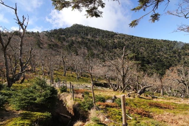
Mt. Hakkyō (aka Mt. Hakken) is the highest point of the Omine mountain range, and the tallest peak in the Kansai area. It’s also situated along an ancient Okugakemichi pilgrimage route, offering some of the most unspoiled scenery in western Japan.
The hike:
From the trailhead, take the well-marked path on your right just before the route 309 tunnel. The route follows the left bank of the stream before crossing a cute wooden bridge, where the steep climb up the spur to the ridge commences. It’ll take an hour along an easy-to-follow path to reach the Deai (出会) junction on the main pilgrimage route. There’s a stone marker here indicating that it is a World Heritage site, and the flat area makes for a good place to rest and catch your breath. Turn right and follow the gentle slope up a short climb and descent, followed by another climb through an area of trees toppled from the Sept. 2018 typhoon. The track has recently been cleared of debris and at the top of the next rise you’ll reach Benten-no-mori (弁天の森) at an elevation of 1600m. There used to be a lodging here but now there’s nothing more than a flat place to take a break. Follow the signs to Misen (弥山) and lose altitude quickly down a broad track for 30 minutes to a pass placated with a large statue of En-no-gyōja. Rest here if necessary before the long, steep climb up to Misen. The path starts off on a gentle ascent before reaching a series of wooden stairs. It should take about 30 minutes of tough climbing to regain the ridge line, where it’s another 20 minutes on a narrow path and over a metal stair/ladder to arrive at Misen hut (弥山小屋). Most people overnight here by either staying at the large hut or camping in a broad meadow on an unmarked trail just before the hut. A path continues past the hut to a fork. Head straight to Tengawa or turn right for the short climb to the summit of Mt. Misen, which houses the mountain deity and affords stunning views across a col to the summit of Mt. Hakkyō. To get to the high point, retrace your steps back to the hut and veer right on the path at a stone marker reading 八剣山•前鬼 (Hakkenzan, Zenki). Drop steeply on a heavily eroded path to a col and then climb through two deer-proof gates erected to protect the Siebold’s magnolia flowers. It should take about 15 minutes to reach the summit, punctuated by a huge weathered-signpost in Japanese for 八経ヶ岳. Enjoy the splendid panoramic views on the rare occasion the peak isn’t enshrouded in cloud/mist. Retrace your steps back to the trailhead or turn left at Misen hut for an alternative finish at Tenkawa (a 5-hour descent along a steep trail).
When to go: This hike can be done all year round, but be prepared for lots of snow in the winter. Click here to see what you can expect in January. Please note that route 309 closes from mid-December to mid-April because of snow, so winter hikers will need to take the longer trail from Tenkawa village.
Access: From Abenobashi station (阿倍野橋駅)in Tennoji (天王時), take a Kintetsu train bound for Yoshino (吉野) and get off at Shimoichikuchi station (下市口). From there, take a bus bound for Dorogawa Onsen (泥川温泉) and get off at the Tenkawa-kawai (天川川合) bus stop. You have three options. Take a taxi for 30 minutes to the trailhead, hitch there, or start your hike from here. If you want to hitch, make sure you’re on route 309 and ask your ride to let you off just before you enter the tunnel. Click here for the bus schedule. The lack of buses from Shimoichiguchi make this almost impossible to do as a day trip, but it definitely can be done if you are up to the challenge. If coming by car please note that there is now a 1000-yen parking fee at the western tunnel entrance parking lot.
Digital Map in English (Avenza App): Click here
Level of difficulty: 3.5 out of 5 (elevation change ~900m)
Explore posts in the same categories: ArchiveTags: hiking, Hyakumeizan (百名山), japan, Kansai hikes (関西地方), Mt. Hakken, Mt. Omine
You can comment below, or link to this permanent URL from your own site.
April 24, 2008 at 8:25 am
Looks like and amazing place to hike. I think I’ll wait to do it one summer though.
April 29, 2008 at 5:16 pm
Hakken is an interesting one. It doesn’t appear on Fukuda’s original list as a hyakumeizan as such, but seems to be more recently accepted as a replacement to Sanjo-ga-take as the representative peak of Omine. I imagine this is largely due to the ban on women climbing Sanjo, which would otherwise keep them from completing the list. Frankly, the views from Hakken are much better than Sanjo, so it is a more than worthy replacement.
It is worth noting though that the ban on women climbing Sanjo is strictly enforced, as unpleasant a concept as that might be in the 21st century.
May 8, 2008 at 10:47 am
Oops, I may have posted this in the wrong place, so I am posting this in the Kansai hikes. My partner and I (I am female) will be hiking near Omine-san and want to continue along the ridgeline to Hongu. We have a Omine-san (# 57 map) and we are struggling with which is the best trail to come up to stay away from Sanjo-ga-take-goya. The map shows two trails coming from the north-east of Sanjo-ga-take-goya, with the more eastern trail joining the trail just east of Kosasa-shuku. Would this be the suggested trail for a female to use to get on the ridgeline? We are likely going to try to take a taxi from Yoshino train station to the small town where the trail looks like it starts from, do you know the name of this town on the 169?
Any suggestions as to get back to Tokyo from Hongu? We figure the hike will take about 5 days or so (we are Calgarians who do a lot of distance hiking so this will be an easy hike even with tents and all of our food) and we were going to wing it from Hongu on, but having a plan from Hongu to Tokyo would be good too!
November 19, 2008 at 5:01 pm
Hi,
Does anyone know whether the mountain hut includes bedding etc? Or is it just a hut in which you need your own sleeping bag and mat? We are planning to do this walk at the end of November (hopefully there won’t be too much snow) and want to know what we need to bring.
Thanks
April 11, 2009 at 11:13 pm
Hi Nadine. How did you get a number 57 map of Omine-San? I have been looking for one. Did you have to get it in Japan?
BTW: Did you continue along the ridge line to Hongu and was it any good? I am thinking the same. Lonely planet (“Hiking in Japan”) suggests to go to Zenki-Guchu after visiting the Dainishi-Dake peak. But it seems logical to keep going to Honchu.
July 25, 2016 at 7:54 am
Hi. Thanks for posting the bus schedule link. I’m having a really hard time deciphering it. I’m wondering what time buses leave Tenkawa Kawai for Shimiuchiguchi on weekday afternoons. And what time they arrive in Shimoichiguchi.
July 25, 2016 at 11:18 pm
Martin,
There are two buses in the afternoon. The first one leaves at 3:35pm and the last one leaves at 4:32pm. I hope that helps.
Wes
December 10, 2017 at 4:40 am
Hi, thanks for this post. I have a few questions.
Is the trailhead at all difficult to locate from just before the tunnel on route 309?
The hut near the top of Mt Hakken, is it suitable to stay the night in? I’m planning to watch a meteor show on the summit (or at least somewhere near there), so it’s mandatory that I spend the night on the mountain.
Lastly, do you think hiking this in the winter would be too much for a beginner? I am in good enough shape, and so am not concerned physically, but I lack hiking experience, and only have relatively cheap gear.
If you have time to answer any of these questions, I’d be super grateful. If not, I understand.
Thanks.
December 10, 2017 at 6:18 am
Joey,
When is the meteor shower exactly? If it’s in the summer than you shouldn’t have any trouble locating the trailhead. Winter, however, is another story.
Route 309 is closed in the winter, which means you’d have to hike from the very bottom at Tengawa village. It’s a long, tough hike that should not be attempted for those without extensive winter mountaineering and route finding experience. The mountain gets a lot of snow in the winter and there is already a blanket of white up there.
Misen hut (near the top of Hakken) is also closed for the winter, so you wouldn’t be able to stay inside. It’s only open from Golden Week to the beginning of November.
I hope that helps. Again, in the green season Hakken is a popular and great mountain, but unfortunately it hibernates in the winter!
I hope that helps.
December 10, 2017 at 3:00 pm
Wes,
Thank you very much for the information. You have saved me from a bad and possibly dangerous experience. The meteor shower is on December 14th. I suppose I was foolhardy in thinking I could manage Hakken in the winter, but I really wasn’t sure the difficulty of it, since I’ve heard that some mountains, despite being very high, are really easy to climb, and was just looking for a spectacular place to view the night sky. Thank you again. I truly appreciate the response. I suppose I will set my sights on a more accessible viewing area.
If I can trouble you with one more question, do you think the Choishi-Mishi trail leading to Koyasan would also be too difficult in the winter?
April 28, 2022 at 3:23 pm
“If coming by car please note that there is now a 1000-yen parking fee at the western tunnel entrance parking lot.”
I just rang them, apparently that car park cannot be used anymore, the road there seems to be damaged. Right now you can only go from the Tenkawa-kawai side.