Mt. Watamuki (綿向山)
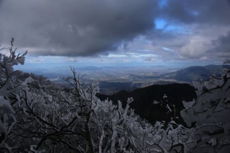
Mt. Watamuki is an 1100-meter tall peak on the western edge of the Suzuka mountains in Shiga Prefecture. The mountain offers outstanding panoramic views and the fresh snowfall in the winter draws large crowds hoping to witness the serene beauty of the rime ice on the trees.
Special Note: Due to the popularity and narrow width of the path, trail running is currently prohibited on this hike. Signs are posted regularly along the route, so expect to be met with resistance if you ignore the rules and decide to run the peak.
The hike: At the bus stop, you’ll find a row of vending machines and not much else. Cross the main road and head up the paved road that runs perpendicular to the bus stop. You’ll immediately see a sign pointing towards Mt. Watamuki (綿向山) and you’ll see another bus stop on your left. This is for a small community bus that will take you to the trailhead. However, this bus is infrequent, so it’s faster to just walk the 3km up the paved road to the trailhead. It’s a straightforward walk, and you’ll see the mountain come into view on your right. Just keep following the signs towards 綿向山 and after about an hour of walking on the paved road, you’ll reach the trailhead at Saimyōjiguchi (西明口) bus stop. Here you will find a restroom (the only one on the hike) and at the toilet entrance there will be a stack of pamphlets with a simple trail map. Turn off the main road and follow this smaller forest road for about 5 minutes until reaching a large parking lot that marks the official start of the hike. If coming by car then you can drive all the way to this point, saving you a bit of walking on the road. The path initially follows the river up a set of steps to a paved forest road, which you will need to follow to its terminus to reach the trailhead, which is marked by a small wooden mountain hut and a large boulder with the kanji characters for 綿向山 carved into it. Head up this path and cross the metal bridge across the river. The path will soon climb steeply, via a series of long switchbacks through a dense cedar forest. After about 10 minutes you’ll reach the first stage point (一合目). There are a total of 10 stage points to the summit but luckily they are spaced a bit closer together further up the mountain. Keep climbing for the better part of an hour until reaching the 3rd stage point (三合目), where you’ll reach a dirt forest road. Turn right here and follow the road for about 50 meters, where the trail will duck back into the forest on your left. You’ll soon reach an open-walled shelter that makes for a good place to escape the elements if you’ve come on a bad weather day. The angle will start to ease a bit as you work your way towards the ridge line, and after about 30 minutes you’ll arrive at a wooden mountain hut with a red roof at the 5th stage point (五合目). Ring the bell in front of the hut and take a minute or two to admire the wonderful views back down towards the valley and Lake Biwa. From here, the trail flattens out a bit and finally leaves the cedar forest behind and enters a wonderful area of old-growth beech trees. If you’ve come in the winter after a fresh dusting of snow, then the tree branches will be alive with wintry crystals. Keep climbing for about 10 more minutes and you’ll reach the 7th stage point (七合目), which is marked by a small wooden alter flanked on either end by a statue of En no Gyojā and Fudō Myō-ō. In ancient times, Mt Watamuki was a training ground for Shugendō monks and there used to be a larger temple in this area. From here, you’ve only got about 200 more vertical meters to go until reaching the summit. If you’ve come in the green season, then continue straight on, following the easy switchbacks (ignoring the junction at the 8th stage point) to the summit. In the winter, however, the summer trail is barricaded off and you’ll see a trail on your left marked at the winter climbing route (冬期ルート). You’ll definitely need crampons on the descent, so it’s a good idea to strap them on now to give you a little extra purchase, especially if the trail is well-compacted and temperatures are below freezing. The path climbs steeply up the spine of the ridge, forgoing switchbacks for a straight-ahead push to the summit. It’ll take about 20 minutes of tough climbing on a wind-swept ridge to reach the high point, which is marked by a large shrine and giant cairn. The views of the Suzuka mountains to the north here are impressive, as you can see the entire range stretched out in front of you. If the weather is clear, you should also be able to see the blue waters of Ise bay, especially in the mountain gap between Mt. Amagoi (the large massif directly in front of you) and Mt. Kama (the pointy peak just to the right on the ridge behind). If you look to the left of Mt. Amagoi, then you can hopefully catch a glimpse of Hakusan, Ontake, and the Japan Alps beyond. The Suzuka mountains are often covered in cloud, however, so views that far to the west are generally limited. You should be able to see the closer peaks of Mt. Ryozen and Mt. Ibuki if the cloud is not in. If you turn towards the right, then you’ll see layer upon endless layer of mountain ridges stretching out to the horizon. These are the mountains of Mie and Nara Prefectures. It’s hard to distinguish one peak from another without some kind of smartphone app that will help you identify the mountains. Anyway, take a well-deserved break on one of the many benches lining the summit plateau (or hide behind a bush if the winds are strong). Apparently, you can keep traversing the ridge to your left for an alternative loop up and over Mt. Ryūō (竜王山), but it’s marked as an expert route and you’ll need plenty of time to make sure you don’t run out of daylight. The path is hard to pick up in the winter, so it’s much better to just simply retrace your steps all the way back to the trailhead.
When to go: This hike can be done year round, but you’ll definitely want to bring some 6-point crampons if climbing between December and March when there is snow on the ground. The summer months can be unbearably hot and humid as well, so the walk is best suited for the shoulders seasons of spring and autumn.
Access: From Osaka or Kyoto stations, take the JR Shin-kaisoku train bound for either Nagahama (長浜) or Maibara (米原) station and get off at Omihachiman (近江八幡) station. From there, go out the Southern exit of the station (南口) and take a bus bound for Kitabatake Guchi (北畑口) and get off at the final stop of the same name. The bus stop is on the right side of the bus rotary and a bus leaves roughly once an hour. Click here for the bus schedule.
Map: Click here. You can also find a paper copy of this same map at the public toilet at the trailhead.
Level of difficulty: 3 out of 5 (elevation change ~1000 meters)
Total round-trip distance: 14km (4 to 6 hours)
Explore posts in the same categories: Archive

Leave a comment