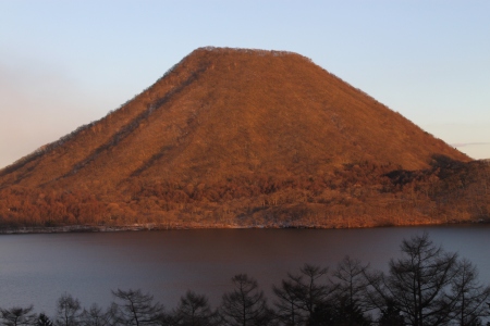
Mt. Haruna-fuji (榛名富士山)
Just as the name implies, Haruna-fuji is a miniature version of Mt. Fuji, with views of the real Fuji from the summit on clear days. Although the top has been wrecked by the addition on a gondola and a TV antenna, the hike through the wonderful bamboo-grass lined deciduous forests is highly recommended.

The hike: From the bus stop, be on the lookout for the visitor’s center, a long, low rectilinear building that has basic information about the mountain. To the left of the visitor’s center is Haruna Lodge, a good place to grab some lunchtime noodles. The trailhead starts just to the right of the visitor’s center, across the paved road. Look for the sign that says 榛名富士登山口. If you got off the stop in front of the gondola, then walk on the paved road to your left (towards the lake), and you’ll find the trailhead on your right. The route is incredibly easy to follow, and if you’ve gone during the week, you’ll likely have the place to yourself. Though the maps say to allow 1 hour to reach the top, if you’re quick and don’t take any breaks, then you can make it in about 40 minutes. The trail is lined with bamboo-grass and verdant foliage. The lack of cedar trees is will be refreshing to those of you used to hiking around the rest of Kanto. The views really open up once you hit the summit plateau, but unfortunately you’ll be staring right at the large building housing the machinery for the gondola. There’s a restroom and vending machine here. Walk past the gondola and turn left, climbing the wooden steps towards Haruna shrine, which sits on the true summit of the mountain. You’ll have wonderful views from here, even if you have to share it with heel-toting tourists who took the easy way up. From the summit, head down the path just to the left of the shrine. The path is marked as Yusuge Motoyu (ゆうすげ・元湯. The route is incredibly steep, so be careful during the cooler months when there is ice and snow on the path. Despite the gradient, the trail is easy to follow, and it will spit you out behind Hotel Yuusuge in about 30 minutes or so. If you’re based at this hotel, then it’s a great place to end. If you’re heading back to Tokyo, then you can loop back around to where you started (or to the bus stop to Takasaki) by turning left when you hit pavement and turning left again. Descend to the lake and follow it clockwise. The trail follows the edge of the lake before skirting the edge of a small side vent emerging from Haruna’s western flank. All in all it should take about 3 hours to complete the entire loop, depending on how many breaks you have taken. You can also combine this hike with Mt. Eboshi if you’re looking for a bit more exercise.
When to go: This hike can be done year round, but you’ll need some 6-point crampons if hiking in January or February. Try to go on a sunny day with clean air and good visibility, as the views are superb. If you visit in mid-December, then you can see the lakeside illumination and fireworks. This is the only time of year where the gondola runs at night. It’s a cheeky way to get to the summit, but it’s really beautiful if you can stand the arctic temperatures. Head up the gondola just before sunset and watch the lights come on from the summit. The night view of Kanto is eye-popping as well.
Access: From Tokyo, take a train to Shibukawa (渋川), and transfer to a bus bound for either Ikaho hot spring (伊香保温泉) or Ikaho-Harunaguchi (伊香保榛名口) and get off at Ikaho Bus Terminal. From here, you can catch a bus bound for Haruna-ko Onsen Yuusuge (榛名湖温泉ゆうすげ). Get off at either in front of the Ropeway (ロップウェイ前) or Lojji Mae (ロッヂ), the next stop. The buses are poorly-timed, so double-check both schedules before you set off, or consider breaking up the trip by staying at the hot spring. Click here for the bus from Shibukawa, and here for the bus that runs between Lake Haruna and Ikaho hot spring. Alternatively, if you’re staying in the area for a few days, then you can simply just stay at the Kokumin-shukusha (recommended), or the more expensive Hotel Yuusuge, which is more convenient for the hike. Either place will pick you up from the bus stop if you’ve taken the bus from Takasaki (see Mt. Kamon hike for a description of that bus route). From the Kokumin-shukusha, you’ll need to walk clockwise around half of the lake to reach the trailhead.
Map: Click here
Live web cam: Click here
Level of difficulty: 3 out of 5 (elevation change ~300 meters)
Distance: 3.5km (2 to 3 hours)
Explore posts in the same categories: ArchiveTags: Gunma, hiking, japan, Lake Haruna, Mt. Haruna, NIhyakumeizan
You can comment below, or link to this permanent URL from your own site.
November 24, 2013 at 10:42 pm
Just wanted to say that your site is great. I’ve recommended it to my friends and reddit among other things. Thank you so much for sharing the information and your love of hiking.
February 18, 2014 at 10:47 am
Thanks Yumi