Posted tagged ‘japan’

Mt. Echigo-komagatake (越後駒ヶ岳)

September 1, 2008

Mt. Echigo-koma is part of the famed ‘Echigo Sanzan’ trio of peaks lying southeast of Minami-Uonuma city in Niigata prefecture. The mountain features wonderful alpine plants, lingering snow fields, and one of the best panoramic views in the Echigo region.

Note: The Urasa approach described in the first part of this hike has fallen into disuse. The path is overgrown and is hard to pick up. Future hikers may want to consider doing the hike as a up-and-back from Shiori-toge, where the trail is easy to follow.

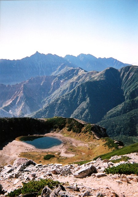
The hike: There’s a small campground at the start of the trailhead called Echigosanzan-shinrin Koen (越後三山森林公園キャンプ場). This is where you should tell the taxi driver to drop you off. The campground is free and unmanned, with a toilet and drinking water with a sign saying it should be boiled before using. There’s a gravel forest road running alongside the tiny campground, and the trailhead is at the end of this road, 3km upstream. The road is in terrible condition, but is relatively flat. About 2km into the hike, you’ll see a small concrete sidewalk on your right with a yellow arrow pointing down. There’s a tunnel here which has been built to bypass the massive snowfield blocking the road. Most of the snow will be gone by September, but use the tunnel if hiking in June or July. The tunnel is short and will meet up with the forest road again, so take your pick if the snow’s gone. About 10 minutes after leaving the tunnel, you’ll find the trailhead on your left. This is where the real hike begins. It’s 5.1km from here to the summit, and the path follows the spine straight up for an agonizing 1500m vertical ascent. It’s not technical or dangerous – just really long and steep. There are no signposts, but the trail is in relatively good shape, as it’s the main traverse route for Echigo-sanzan, as hikers can climb Echigo-koma, Naka-dake, and then Hakkai san before descending to a point not far from here. The first hour or so is pretty straight-forward until reaching Yukimi-no-matsu (雪見ノ松), a huge pine tree with outstanding views of Mt. Hakkai across the valley. Your next landmark is in another 2 hours or so, where you’ll find a small sign reading Rikimizu (力水), but there’s no water source here. Keep climbing for another 10 minutes or so and you’ll finally reach a ridgeline, where you’ll find your first views of Naka-dake. The summit of Echigo-koma is to your left, hidden by a large, pointy peak between you and the summit. This peak is labeled as Gushigahana (グシガハナ) on the map, but there’s no signpost on the summit. It’s a sweaty, steep one-hour climb. Just before the top of Gushigahana, the trail becomes overgrown with bamboo grass and very steep, with lots of large pine trees holding the ridgeline in place. Once you reach the top you’ll have your first view of the summit of Echigo-koma, and it’s an easy 40-minute hike away. The trail flattens out signficantly, so relax and enjoy the awesome views. In about 20 minutes or so, you’ll reach the true ridgeline for the Echigo-sanzan traverse, so turn left and head towards the summit of Echigo-koma. Just before the top you’ll find a trail branching off to the right. This goes down to Koma hut (駒ノ小屋), your accomodation for the night. Take in the scenery from the summit and ring the small temple bell on the summit, saying a prayer to the mountain gods for good weather. Retrace your steps back to the junction and turn left for the short 10 minute descent to the hut. A place to sleep on the floor will cost you 2000 yen, and there’s a caretaker there on weekends to collect money. Otherwise, there’s an honesty box to drop your money in. There’s no food here, so you’ll have to bring a stove and a sleeping bag. They do, however, have lots of silver sleeping mats and some blankets, so there’s no need to pack a sleeping mat. There’s also a clean toilet (bring your own toilet paper) and plenty of fresh water. The water is safe to drink but may run out in the autumn once all of the snow fields have melted. Enjoy a good night’s rest, and the next morning take the trail that descends just below the water tap. It’s pretty steep at first, but then flattens out nicely for a much easier (and popular) trail then the previous day’s climb. The maps say to allow 4 hours for the descent to Shiori-toge (枝折峠) but you can do it in half the time if fit. Your first landmark will be the top of Mae-koma (前駒), where the trail continues dropping off before flattening out. There’s a small lake in this saddle, followed by another descent to a trail junction on the summit of Mt. Kokura (小倉山). Turn left for an alternative finish at Koma-no-yu hot spring. Otherwise, continue on the same trail towards Shiori. About 30 minutes further on, you’ll see a junction on your right. It’s a short spur trail to the summit of Mt. Michiyuki (道行山), which has a nice view back to Echigo-koma. If the cloud is in you can just ignore this spur and continue descending. The next landmark will be a shrine, which looks remarkably like an emergency hut. Shortly after passing by the shrine, you’ll find a trail junction on your left marked as Kin-no-michi (金の道). This trail will take you to Kuma-no-yu hot spring in about 2 hours or so. Ignore this junction and continue on, where you’ll find a junction with another Kin-no-michi signpost. This trail to the right leads down to Ginzan-daira (銀山平), which has its own hot spring and plenty of accomodation. This is the trail I took, and it’s really well maintained and divided into 10-stages. It pretty much parallels route 352, but is much more beautiful than hiking down to the pass. At the 3rd stagepoint (三号目), you’ll reach a gravel forest road. Turn left and walk about 20 meters and the trail will drop off on the right side of the road. Take this trail and you’ll reach another forest road at the 2nd stagepoint (二号目). Turn right and cross the concrete bridge over the river. The road will become completely overgrown but don’t worry – keep going because it’s a short-cut to the hot spring. After a few minutes you’ll reach a paved road. Turn right for the 10-minute stroll to the hot spring. There are a lot of cabins and mountain huts, but the hot spring is on the left, in a large 2-story building. A soak will cost 650 yen and there’s a fresh water spring out front with drinkable spring water. You can either stay at one of the huts in this ‘village’ or walk back to route 352 and try your luck hitching. If you’d like to hitch, then I’d recommend turning right on route 352 and walking about 2km to the lake. Just past the trailhead to Mt. Arasawa (荒沢岳), you’ll reach an intersection. Turn left and wait just before the tunnel. Most vehicular traffic uses this long tunnel nowadays, and not so many cars pass by Shiori-toge.

When to go: This hike can be done from June 1st to October 19th, when the bus to Shiori pass is running and route 352 is open to traffic. It’s nearly impossible to do this hike before June, as the road is still covered with meters of snow and avalanche danger still high on the Urasa approach. However, Ginzan-daira (銀山平) is accessible by car from Golden Week onwards, but be prepared for lots of snow if attempting a May ascent.

Access: If you’re doing the traverse, then there’s no bus transport to the trailhead, and you’ll have to shell out around 3500 yen from a taxi at Urasa (浦佐) station. Otherwise, if you’re doing the up-and-back approach from Shiori-toge (枝折峠), then there’s one bus a day leaving from Koide (小出) station. Unfortunately, this bus leaves at 6:30am, meaning you’ll have to either stay overnight at Koide station, or take the overnight bus from Ikebukuro station in Tokyo, which arrives at Koide at 3:15am! Click here for the bus schedule. The bus from Shiori back to Koide leaves at 4:35pm.

Live web cam: Click here

Level of difficulty: 4 out of 5 (elevation change ~1700m).

Mt. Shiomi (塩見岳)

August 26, 2008

Last updated: August 18, 2017

This blog post was updated in 2017, but if you’re looking for the latest information about this hike (including color photos and maps), please consider purchasing my guidebook to the Japan Alps. 

Mt. Shiomi is a rugged, twin peak situated roughly halfway between Kita-dake and Mt. Warusawa in the Minami Alps. The panoramic views of Mt. Fuji and the Chuo Alps are incredible in favorable weather.


The hike: From the bus stop, take the trail just to the left of the hiking registration box and enter the forest. The route is divided into 10 stages and is clearly marked with signposts counting up from 1. It climbs steeply for about an hour to a ridge, where’s there’s a long traverse along a path loaded with wooden stairs and precarious walkways. Just before the 9th stagepoint (9/10) you’ll see a roped-off junction on your left that leads down to Shiokawa. This used to be the main trail up to the pass before the road was washed out in a typhoon. Continue on for another 30 minutes and you’ll reach Sanpuku-tōge (三伏峠), the tallest mountain pass in Japan. It should take about 4 hours or so to reach the mountain pass, where you’ll find an excellent mountain hut and campground. Sanpuku-tōge hut (三伏峠小屋) is open from July 1st to September 30th and charges 8500 yen for 2 meals or 5500 yen for sleeping space only. Click here for the website. I’d really recommend staying here, as it helps break up the very long climb of Mt. Shiomi and makes for a good base camp. The only drawback is the lack of drinking water. You can either buy bottled water from the hut or hike 20 minutes down the trail to get water. From the hut, turn left and walk past the campsite until reaching a junction. Turn left towards Mt. Shiomi (塩見岳). The trail drops to a saddle before climbing up to the treeline and the summit of Mt. Sanpuku (三伏山), which provides wonderful panoramic views in clear weather. If the weather is fine then you’ll see Mt. Shiomi towering above you across the valley and you’ll realize just how far you need to go. Continue along the ridge towards Mt. Shiomi and you’ll eventually drop down to the tree line and start losing altitude, where you’ll meet a junction with a closed trail on your right. This trail used to lead down to the old Sanpuku hut and campsite, which is now closed. Climb the steep trail in front of you past some wildflowers and after about a half an hour of steady climbing you’ll reach the summit of Mt. Hontani (本谷山), which also pokes out above the treeline. On the left-hand side of the summit you can see Kitadake through a clearing in the creeping pine. Keep to the ridge and you’ll once again drop down to a lush forest and reach a low point, where the trail will veer towards the right for a very long traverse towards Shiomi hut (塩見小屋), which sits perched on the edge of the treeline. Just before reaching the end of the trees, veer right at the junction marked for 塩見小屋 and follow the switchbacks through the creeping pine. It should take about 90 minutes from the saddle below Hontani to this hut, which makes for a great place to catch your breath before the final assault on the steep western face of the peak. The hut was completely rebuilt in the summer of 2016. It is now a clean hut with very friendly staff. Reservations are required to stay here, but they might be able to accommodate you if you show up early and they’re not fully booked. From the hut, the trail starts climbing towards the summit of Tengu-iwa, but just before reaching it there’s a traverse path on the right that skirts the edge of the mountain through a large maze of rocks. The route is easy to find in clear weather, but when the cloud is in then look for the yellow paint marks on the rocks. After reaching the far side of Tengu-iwa, you’ll get your first views of Mt. Shiomi in all its intimidating splendor. It’s hard to believe there’s actually a trail up that mass of rock on a nearly vertical face but rest assured – there is a path. Drop down to the saddle and carefully pick your way among the maze of yellow paint marks. There’s one section at the start of the climb that is susceptible to rockfall from hikers above, so make sure you keep your eyes and ears peeled for any falling stones. It’s a thrilling, somewhat precarious climb of around 45 minutes until you magically pop out on the summit plateau and can once again walk on relatively horizontal ground. The first summit is the western peak (西峰), which is just a few meters lower than Shiomi’s twin summit Tōhō (東峰) which is fortunately an easy walk along the ridge for another 5 minutes. After admiring the views, retrace your steps all the way back to Sanpuku-tōge, or continue along the ridge for another couple of hours to Kumanodaira hut (熊ノ平小屋), which will set you up nicely if you plan on continuing on to Kitdake the following day.

When to go: This hike can be done from mid-July to late August, when the bus to the trailhead is running. If you’ve got your own transport, then you can go much earlier/later than this. Alternatively, you can approach via Kita-dake, but you’ve got to be careful if descending to Torikura if you’re out of bus season as it’s an awful long way from anywhere.

Access: From Okaya station (岡谷駅) in Nagano Pref. take the JR Iida line (JR飯田線) and get off at Ina-Oshima (伊那大島) station. The local train takes about 90 minutes. From there, take a bus bound for Torikura tozanguchi (鳥倉登山口) and get off at the last stop. The bus stop used to run to a place called  Shiokawa (塩川), but the road has been washed out and there’s no plan in the immediate future to rebuild it. This bus only runs from mid-July to the end of August, and there are only 2 buses a day. Click here for the schedule. My advice would be to take the last train to Ina-Oshima and either sleep at the unmanned train station or at the bus stop. The bus stop is sheltered with a long bench, making it perfect as a place to sleep. Just bring your sleeping bag. That way, you can easily catch the 6:45am bus! If you’re hiking out of the bus season, then you could pay 10,000 yen for a taxi ride to the trailhead.

Be careful if approaching this hike from Nagoya, because the JR Iida line from Toyohashi station takes over 5 hours to get to Ina-Oshima! It’s much faster to take the JR Chuo line and change at Shiojiri.

Level of difficulty: 5 out of 5 (elevation change 1717m).

Mt. Rishiri (利尻山)

August 23, 2008

Mt. Rishiri is a spear-like, volcanic peak towering off the coast of Northern Hokkaido. It’s one of the few mountains in the world that offers an unobstructed panoramic view of the ocean on all sides.

The hike: From the campground, follow the paved path towards Kanrosen (甘露泉) spring, an underground spring with refreshing water. It should take about 10 minutes or so to reach the spring. Fill up your water bottles here, as it’s the last water source on the hike. Just beyond the spring there’s a sheltered rest area with a picnic table, as well as a trail junction. Turn right at the junction and follow the well-worn path through the forest. You’ll reach the 4th stage (四合目) in about 15 minutes or so. It’s a gradual climb for about an hour or so before reaching the 6th stage (六合目), where the real climb begins. There’s a toilet box here for those needing to use the facilities. Pick up a toilet bag at the trailhead to use for poop (there are no toilets on the mountain, and you’ve literally got to pack your shit out!). From here until the 8th stage (八合目), it’s a tough slog through brush pine and rocks, but eventually you’ll hit the ridge line, and your first real view of the summit. There’s still a lot of climbing to do, and the peak looks so close yet so far away. From the 8th stage, the trail flattens out before dropping down to the emergency hut, situated on a saddle. If there’s any morning dew then you’ll get completely soaked with all the overgrown vegetation, so consider bringing a pair of rain pants to help soak up the moisture. The emergency hut is in really good condition, bu t there’s no water source here, so bring a ton of water, sleeping and cooking gear if planning to stay here. From the hut, you’re faced with a 500m vertical climb through loose scree and red boulders. It gets quite steep and slippery in places, but there are ropes to help you along. At the time of writing they were in the process of building steps in some of the trickier sections, which will definitely make things easier if they don’t get washed away by erosion. Eventually you’ll reach the small summit of Mt. Rishiri, which has a colorful shrine and room for about 10 people. The panoramic views are absolutely amazing if you’re lucky enough to climb when the weather is good. From the summit, retrace your steps all the way back to the parking lot. Alternatively, you could take the seldom used Kutsugata (沓形) track to descend down to Kutsugata port. The trail junction is relatively hidden, branching off to the left shortly after descending the steep section with lots of red rocks. The trail is quite precarious in places, and not for the inexperienced or acrophobic.

When to go: This hike can be done from late June to early October, when most of the snow is gone. A spring hike is also possible with an ice axe and crampons, but keep an eye on the changeable weather.

Access: From Wakkanai (稚内) station, take a ferry bound for Oshidomari (鴛泊) on Rishiri Island. There are only 4 ferries a day, so plan your time accordingly. Click here for the schedule. From Oshidomari port, you can either hike uphill for about an hour to the trailhead, or catch a taxi for 1490 yen. There’s a nice campground at the trailhead that costs 300 yen per person.

Live web cam: Click here (from Rebun Island)

Map:

Level of difficulty: 5 out of 5 (elevation change ~1500m).

This slideshow requires JavaScript.

Mt. Shari (斜里岳)

August 21, 2008

Mt. Shari is a pointy, rocky peak situated roughly halfway between the Akan lake volcanoes and the Shiretoko Peninsula. The views from the summit towards the Sea of Okhotsk and Pacific Ocean are awe-inspiring.

The hike: From the massive parking lot, take the trail that starts next to the hut. It cuts through a pine forest before quickly dropping to a gravel forest road! Turn left on the road and follow it for about a half a kilometer. The road hits a dead end, where the actual trail starts. This is where the original hut used to stand before the new one was built. Anyway, turn left into the forest. The path follows a beautiful stream for a short time and you’ll soon reach the first of 12 river crossings. There are rocks that you can step on to make your way across, so there’s no need for special shoes and for getting your feet soaked. However, if it’s been raining recently and the stream is swollen then you’ll definitely get wet on the crossings. Shortly after completing the last crossing you’ll reach a trail junction. You have two options, but I recommend doing this trail as a loop by climbing up the left path and descending via the right path. The path to the left is the Kyuudou (旧道 – old path) and the trail on the right is the Shindou (新道 – new path). The old path is also known as the waterfall route, as it basically climbs past countless waterfalls. Again, if the stream is swollen then you might want to consider avoiding this path. Take a left and you’ll soon reach your first waterfall. There are another half a dozen stream crossings along the way, and plenty of ropes and chains in the tricky sections. Overall it’s not too terribly difficult if you’ve got shoes with good traction. After about an hour of climbing the stream will start to peeter out and you’ll come across a junction. This is where the old and new paths meet to become one trail to the summit. It’s marked with a sign written as Kamifutamata (上二股). There’s a small flat space that has room for one tent and it’s probably the only place to pitch a tent on the entire mountain. Stay to the left for the steep climb up to Uma no sei (馬の背 – the horse’s back) where you’ll find your first view of the summit. Turn left again and climb up the steep peak just in front of you. It should take about 10 minutes to reach the top, where the path will flatten out and you’ll pass a small shrine. Drop down to a saddle just below the summit and climb steeply for another 20 minutes or so before reaching the top of Mt. Shari. The scenery on a clear day is fantastic, with a bird’s eye view of the town of Shari, the Sea of Okhotsk, Mt. Rausu, Kunashiri island, and even out to Mt. Meakan! Retrace your steps all the way back down to Kamifutamata and turn left. The trail is relatively flat at first, passing by a trail branching off to the right. You can either take the right trail that passes by a small pond or continue going straight. Both paths will meet up later on, so take your choice. This area definitely looks like bear country, so use your bear bell if you’ve got it. Shortly after passing the loop trail turnoff, the path will climb up to a mountain pass called Kumami-toge (熊見峠). The scenery is very reminiscent of the Japan Alps, as you pass through an area of brush pine with wonderful views over to the summit. After reaching the pass, the trail drops very steeply back down to the stream. On your way down take a look at the trees lining the path, as their branches have been stained with sweaty by countless hikers grabbing onto them. It’s kind of interesting to see how many hikers have grabbed the tree branch in exactly the same place! You’ll reach the original trail junction in about 30 minutes or so, and turn left again to go back to the forest road you started on. Overall, it’s a 9km round-trip hike that should take you anywhere from 4 to 6 hours, depending on your speed.

When to go: This hike can be done from late June to early October when most of the snow is gone. A winter ascent is also possible with the right equipment and experience. There’s a sign at the trailhead prohibiting hikers from starting after 12 noon, so it’s imperative that you arrive at the trailhead in the morning. It’s a stupid rule that the hut manager does his best to enforce. If you arrive in the afternoon, then you can stay at the concrete bunker known as the Kiyodake hut (清岳荘) for 2000 yen. There are no meals served nor is there any drinking water. You’ll either have to boil and filter the water coming out of the sink or buy expensive bottled water from the hut manager.

Access: From either Kushiro (釧路) or Abashiri (網走) stations, take the JR Senmo Line and get off at Kiyosatocho (清里町). From there, take a taxi to the Mt. Shari trailhead. The station is small and unmanned, so call the Kiyosato taxi company at 01522-5-2538 and they’ll pick you up. The taxi costs roughly 4000 yen. Hitching is pretty difficult because the road is gravel and used only by people climbing Mt. Shari, who usually arrive at the trailhead at unreasonable hours! Hitching from the trailhead, however, is relatively easy.

Live web cam: Click here

Map: Click here

Level of difficulty: 4 out of 5 (elevation change 857m).

Mt. Washiba (鷲羽岳)

July 27, 2008

Mt. Washiba, or ‘eagle feather’ mountain, is a glorious alpine peak lying on the Nagano-Toyama border in the Kita Alps. The granite peak is famous for its mysterious volcanic crater lake, situated just below the summit.

The hike: From the bus stop at Shin-hotaka, cross the bridge and follow the paved road toward the right. It’ll climb past the Hotel New Hotaka (ホテルニューホタカ) before turning into a dirt forest road. The road is really easy hiking, following a river. Follow the road for about 90 minutes, being careful not to take the trailhead to Mt. Kasa. You’ll pass by a campground and hut at Wasabi-daira (わさび平) before finding the trailhead another 20 minutes up the road. The trail starts climbing up a cirque, and after about 2-1/2 hours will reach a junction called the Kagami-daira bunki (鏡平分岐). Take the trail to the left if you’d like to climb directly up to the ridgeline towards Mt. Yumiori (弓折岳). Both trails eventually meet up on the Yumiori summit, so it might be better to stay to the right, so you can see the phenomenal reflections of Mt. Yari in the mirror lake at Kagami-daira. Kagami-daira hut (鏡平小屋) is open from July 10th to October 15th and has no campground. Click here for the website. Most people stay here for the night, but if you’ve brought a tent or it’s still relatively early in the day, you can continue on to Sugoroku (双六), which is another 2 hours away. Continue climbing on the same trail and you’ll reach Mt. Yumiori. From here to Sugoroku it’s a relatively easy ridge walk with wonderful views. Sugoroku hut (双六小屋) is run by the same people as Kagami-daira and offers exactly the same prices, but has the added advantage of a large campground. Use this as your base for exploring the surrounding peaks. The next day, follow the trail in front of the hut towards Mt. Sugoroku (双六岳). You’ve actually got 2 options. You can either climb up to the peak and stay on the ridge line to the summit of Mt. Mitsumata-renge (三俣蓮華岳) or you can opt for the easier shortcut trail that bypasses all of the peaks. Just take a right at the first trail junction you see after leaving the hut. Both trails meet up at the same place, so take your pick and head towards Mitsumata hut (三俣山荘). You’ll find another campground at this hut, as well as a water source. The hut sits at the foot of Mt. Washiba (鷲羽岳), and you’ll see it towering directly in front of you. It should take about an hour or so to reach the summit, where you’ll pass by a spur trail leading down to the volcanic crater lake. On a clear day, you can see all of the Kita Alps, including the peaks of Hakuba and Tateyama, as well as Mt. Yari, Hotaka, Kasa, Yake, Norikura, and out to Ondake. From here, you can either continue on the same ridge line over to Mt. Suisho (水晶岳), which is also one of the 100 famous mountains, or retrace your steps back to Sugoroku. The options for multi-day traverses are endless, and if you’ve made the effort to climb all the way up here, you might as well stay on the ridge line for a few days.

When to go: This hike can be done from late May to early November. Just like the neighboring peaks of the Kita Alps, Mt. Washiba is considered an expert climb in the winter, and challenging even during Golden Week because of all the remaining snow.

Access: From Takayama (高山駅) station, take a bus bound for Shin-Hotaka Hot Spring (新穂高温泉) and get off at the last stop. Click here for the bus schedule. There are also buses from Matsumoto station (松本駅) in Nagano, and there may even be direct night buses from Tokyo.

Level of difficulty: 5 out of 5 (elevation change ~1900m)

Mt. Iide (飯豊山)

July 23, 2008

Last updated: Feb 18, 2025

Mt. Iide is without a doubt the best multi-day hike in the Tohoku region. The stunning scenery and abundance of mountain huts attract a large number of hikers in the summer months.

The hike: From the bus stop, hike through the small town and onto a gravel forest road. If you’ve hired a taxi then it’ll take you directly to the trailhead, saving this 30-minute walk. At the end of the road there’s a campground and small hut with hiking information. The trail is clearly marked and starts off as an extension of the road you’ve been hiking on. Soon enough it’ll branch off to the right, and this is where the real hike starts. It’s one heck of a climb, with a 1200 vertical meter elevation gain before reaching the ridge line! The maps say it’ll take 5 hours to reach the first hut of the day (at Mikuni-dake), but if you’re in shape you can do it in about 2 hours or so. The trail is very well-trodden, with lots of tree roots to climb up and over. The forest is all virgin beech, and the greenery is stunning. You’ll reach a water source at a place called Nakajugori (中十五里), but it’s not a reliable source of water (it’s a 5 minute hike down a spur trail to the right, and the water was just barely trickling out in mid-July). It’s better to fill up your bottles at the trailhead. A bit further on, after passing Sasa-daira (笹平), you’ll see an unmarked trail branching off to the right. Ignore this trail, as it’s an alternative way up the mountain and continue climbing toward the left. In another 10 minutes or so, you’ll reach another trail junction. You can either head right to climb to the summit of Mt. Jizo (地蔵山), or take the easier spur trail to the left. I’d recommend taking the left trail, because it passes right by a nice water source gushing with refreshing water. You can also see the ridge line of Mt. Iide rising up on your left. Soon after passing by the spring, you’ll meet up with the trail coming from Mt. Jizo. Turn left and follow the rocky ridge line towards Mt. Mikuni (三国岳). This trail is easy to find in clear weather, but could be a bit tricky if the fog is in, as there are no paint marks on the rocks. My advice is to follow the rocks that have scuff marks on them. This is not a place that you want to fall, but if you keep climbing then you’ll eventually pop out on the summit ridge, and they’ll be a hut awaiting you! If you’re set on a 3-night, 4-day hike, then check into the hut and enjoy the scenery. None of the huts on Mt. Iide have food or blankets, so you’ve got to bring a sleeping bag, stove, and food. The only downside with staying at Mikuni is that there’s no reliable water source, so if you’ve got extra time or energy, it’s better to push on for another 90 minutes to Kiriai hut (切合小屋), which has plenty of water. The ridge line between Mikuni and Kiriai is tricky, with a few chains in places, but the closer you get to Kiriai the easier it gets. You should also see your first set of snow fields. Just before the hut you’ll see a trail coming in on the right. This is another alternative way up the mountain, and very popular with people because it’s the shortest route up. If you’re a sucker for punishment, then you can continue another 90 minutes or so to Honzan hut (本山小屋). The trail will climb through a long snow field, and then drop steeply on the other side to a saddle, where you’ll find a Jizo statue. Then it’s a long, endless slog up to the hut. Most people take 2 days to reach this hut, but I made it in only 5-1/2 hours from Kiriai to this point. The hut manager is very friendly, and a place on the floor costs 2000 yen. All of the huts on Mt. Iide charge similar prices, but all have places to pitch your tent as well. From Honzan hut, it’s a 20-minute hike to the top of Mt. Iide, which is far as most hikers go. However, part of the beauty of this mountain is to traverse the entire length. It’s only 34.5km from end to end, and can be done in 3 days without a problem. Anyway, continue past the top of Mt. Iide, towards Mt. Dainichi (大日岳), the highest peak in the entire range. If the weather has been good then you’ve probably been staring at it ever since arriving at Mikuni! It should take about an hour or so to reach the trail junction at Onishi hut (御西小屋). You can leave your pack outside of the hut for the up-and-back assault of Mt. Dainichi. The maps say to allow 2 hours to reach the summit, but you can easily make it up and back in that time if you’re fit. You’ll have to cross a small snow field along the way, so take extra care if the snow is icy. The scenery is outstanding, as the Fuji-esque silhouette of Mt. Bandai stretches out in front of you. You can also see the peaks of Nikko National Park on a clear day, as well as Mt. Asahi, Gassan, and Mt. Chokai. Mt. Sado and the Sea of Japan will also greet you to the west. Head back down to the hut, where it’s time to make a decision. The next hut is 3 hours away, on a relatively flat ridge line. Keep pushing on if it’s early or you aren’t too worn out. There are a lot of snow fields to cross in this next section, so if you’re not confident then consider bringing a pair of light crampons to help boost your confidence. Climbing is no problem. but descending can be a bit slippery depending on snow conditions. Also, the track is a little difficult to follow in foggy weather, but luckily it’s well worn, so when in doubt always look for the footprints in the snow. You’ll pass by a few magnificent alpine lakes before reaching the summit of Mt. Eboshi (烏帽子岳). From here it’s a big descent to Kairagi hut (海花皮小屋). There’s plenty of delicious fresh water here, so take a break and check into the clean, beautiful hut if you’ve chosen this as your place to spend the second (or third) night. There’s a trail leading straight down the valley directly in front of the hut, but this is for climbing only (it’s one of the famous cirque climbs in Japan, up a very long and steep snow field). The next big climb is to the summit of Mt. Kitamata (北股岳), where you’ll find a small shrine. This is the highest peak in the northern section of the Mt. Iide mountain range. From here, it’s a relatively easy traverse over to Mt. Monnai (門内岳). Here you’ll find the final hut on the traverse. Check-in here, or push along for the 4-hour knee knocking descent down to Iide hut (飯豊山荘), with it’s lovely hot spring bath! To get there, continue on the ridge for about 20 minutes and you’ll find a trail junction. Turn right and follow the trail, down 1400 vertical meters. It’s quite steep, but there are plenty of tree roots to grab onto. There’s a water source about halfway down the descent. Take the short spur trail on the left in order to reach it. Remember the bus schedule before you set off for Iide hut. If catching the afternoon bus, then head down early enough too enjoy a 500 yen bath. It’s also possible to stay at the hut for 1700 yen (including use of the hot spring) if you tell them you’ve got your own sleeping bag and food. It’s also possible to continue along the ridge line all the way to Mt. Eburisashi (朳差岳) one of the 200 famous mountains of Japan. As it’s a 10km traverse from Monnai, you’ll need an extra day to reach it. Also, there’s no bus service from Oku-tainai (奥胎内) at the end of the hike, so you’ll have to fork over 9000 yen for a taxi.

When to go: This hike can be done during July and August only, when the buses are running. If you’ve got your own transport then you can do it in June or September. This mountain gets a ton of snow in the winter, so it’s better to avoid unless you’re training for Mt. Everest or something.

Access: From Niitsu (新津) station, take a train on the Banetsu-sai (磐越西) line bound for Aizu-wakamatsu (会津若松) and get off at Yamato (山都) station. From there, take a bus bound for Kawairi (川入) and get off at the last stop. There are only 2 buses a day running from mid July to mid September , so it might be better to shell out 7000 yen for a taxi if you miss the 8:50am bus. Click here for the schedule and call 0241-38-2025 to double check the 2025 schedule.

At the end of the hike, take a bus from outside of Iide-sanso (飯豊山荘) bound for the hospital (病院前) and get off at Oguni (小国) station. Again, there are only 2 buses a day, so make sure you’re off the mountain by 9am to catch the morning bus, or you’ve got to wait around (at the hot spring) all day. Click here for the schedule.

Map: Click here

Level of difficulty: 4 out of 5 (elevation change ~1722m).

Mt. Oku-dainichi (奥大日岳)

July 16, 2008

This blog post was written back in 2008. For the latest information about this hike (including color photos and maps), please consider purchasing my guidebook to the Japan Alps. 

Mt. Dainichi is a fantastic alternative for those who don’t have the experience or skills for climbing the ‘tough’ peaks of the Kita Alps. In fact, it could possibly be the perfect peak for absolute beginners, as there are no chains or ladders or vertigo-inducing cliff faces.

The hike: From the bus terminal at Murodo, follow the winding, paved path towards Mikuri Lake (みくりが池) and Raicho-daira (雷鳥平). It should take about a half an hour to descend down to the campsite and huts. Fill up on water here, as there’s no water source for the rest of the hike. From Raicho-daira, cross the river and turn left at the junction, following the paint marks and wooden planks towards Mt. Oku-dainichi (奥大日岳). In fine weather it’s pretty easy to see where you’re going, but it can be a little tricky if there’s a snow field or if it’s foggy. The climb is pretty gentle and you should be on the main ridge line in about 40 minutes or so. Turn left at the junction for the start of the climb up to Mt. Dainichi. There are a number of different peaks that you’ll climb up and over before reaching the summit, but the trail is well marked and easy to follow. Keep your eyes peeled for ptarmigan, as there are quite a few on this mountain. In good weather you’ll have outstanding views of both Mt. Tateyama and Mt. Tsurugi, the sea of Japan and Toyama city, as well as Hakusan off in the distance. It should take about 2 hours to reach the summit of Oku-dainichi, the highest peak in the Dainichi range. If you’re only doing a day hike, then you can rest here and retrace your steps back to Raicho-daira. However, a more interesting alternative is to keep traversing on the ridge, over to Mt. Dainichi. It should take another 2 hours of gentle up and down hiking to reach the peak, where you’ll find Dainichi hut (大日小屋). This hut is known as the “lamp and guitar” hut, and it’s open from July 1st to the middle of October. It’ll cost 8400 yen with 2 meals, or 5500 yen for a room only. Click here for the web site. The next day, you can simply continue along the ridge line and drop 1600 vertical meters down to Shoumyou Waterfall (称名滝), a huge waterfall that rivals any found in Yosemite National Park. There’s a bus back to Tateyama station (立山駅) from the waterfall, which means you’ll completely avoid the Tateyama-Kurobe Alpine Route on your way back. Click here for the bus schedule.

When to go: This hike can be done from mid July to late November, when most of the snow will be gone. It’s possible to go earlier if you’ve got crampons, but for beginners it’s better to wait until August when the most of the snow fields will be melted.

Access: From Dentetsu Toyama station (電鉄富山駅) take a local train bound for Tateyama (立山) and get off at the last stop. From there, change to the Tateyama-Kurobe Alpine Route, taking a cable car and then bus to Murodo (室堂). Click here for English information, including a detailed timetable.

Level of difficulty: 2 out of 5 (elevation change ~400m).

Mt. Zao (蔵王山)

July 16, 2008

Last updated: Feb 17, 2025

Mt. Zao is one of the most popular ski resorts in Japan, and home of the famous ‘snow monsters’. In summer, it’s an easy stroll via a picturesque volcanic lake, and the hot springs at the base of the mountain are an added bonus to help rejuvenate tired muscles.

The hike: There’s no doubt about it. The ease of access will bring huge swaths of crowds in the summer months, but with a little timing you can have some peace and solitude. My advice would be to arrive at Katta-toge in the early evening and stay at the stone emergency hut at the summit of Mt. Katta (刈田岳). The hut is unmanned and completely free to stay in. Bring your own water and be prepared for a 10 minute walk to use the toilets at the parking lot. This way, you can wake up at the break of dawn and enjoy a wonderful stroll without a soul in sight. From the huge parking lot, follow the well-marked trail towards Mt. Kumano (熊野岳). Along the way, you’ll pass by a stunning volcanic lake on your right, named Okama (御釜). The emerald green colors are breathtakingly beautiful (or so I’m told – I was unfortunate because the lake was completely hidden in thick fog!) Click here to get an idea of the scenery in good weather. Continue on the same trail for a gentle climb, taking a left at the only junction you’ll find. You’ll be on the summit of Mt. Kumano in about 20 minutes, where the views are stunning in nice weather. Yamagata city stretches out directly below you, framed in the distance by Mt. Iide, Mt. Asahi, and Gassan. From the summit, you can either retrace your steps back to Katta-toge, or descend down to Zao Onsen via the long ski resort. I recommend the latter option as the only bus from Katta-toge doesn’t leave until 1pm. The path through the ski resort is well-marked, and just before you take the final descent toward the very bottom of the lift, look for a bridge branching off to the right, which will take you to the ‘big bath’ (大露天風呂), a fantastic outdoor bath with milky white water. Unfortunately it’s not open in the winter, because there were problems with peeping Toms from the ski runs above. It’s definitely one of the highlights of Zao hot spring, so don’t miss this chance! Click here for more info.

When to go: This hike can be done year round if you’ve got some snowshoes. In fact, I’d recommend combining this hike with a weekend on the ski slopes. If the weather is good, then you can take the gondola up to JIzo-sancho (地蔵山頂) and hike for one hour via a route marked with huge poles to the summit of Mt. Kumano (熊野岳). Otherwise, you can opt for an easy stroll from the trailhead at Katta-toge.

Access: From Yamagata (山形) station, take a bus bound for Zao Onsen (蔵王温泉) and get off at the Zao Onsen bus terminal (蔵王温泉ターミナル). The bus takes about 30 minutes and leaves once an hour. Click here for the schedule. There’s only one bus a day going directly to the trailhead at Katta-toge (刈田峠) and it only runs in the summer. If you miss this bus, then just take a regular bus to Zao Onsen and either hitchhike from there or take a taxi. (or start your hike from there for the 1000m vertical ascent to the summit).

Digital Map in English (Avenza App): Click here

Level of difficulty: 1 out of 5 (elevation change ~200m).

Mt. Oku-hotaka (奥穂高岳)

July 1, 2008

This blog post was written back in 2008. For the latest information about this hike (including color photos and maps), please consider purchasing my guidebook to the Japan Alps. 

Mt. Oku-hotaka is the 3rd highest peak in Japan and one of the most exhilarating climbs in the Kita Alps. The views are phenomenal on the rare occasions when the cloud isn’t in.

The hike: From the Kamikochi bus terminal, follow the paved path and signs towards the famous Kabba-bashi bridge. Cross over the bridge and head past all of the hotels. The path is well-marked, with plenty of wooden planks to keep people from trampling the flora. You’ll reach a trail junction in about 10 minutes, so head left for the long climb up dakesawa (岳沢). The path follows the beautiful gully for about 2-1/2 hours before reaching Dakesawa Hut (岳沢ヒュッテ). This hut was badly damaged in an avalanche in 2006 and is closed, but snacks and drinks are sold to hikers during the main hiking season (July to October). There are no plans to re-open this hut again. After leaving the hut, the path curves towards the right and gets quite steep, with lots and lots of switchbacks. It’s really tough going if you’ve got a heavy pack, so take your time and stay hydrated with lots of fluids. There are several places with chains and ladders along the way, so take extra care during wet weather. It should take about 3 hours or so to reach the trail junction just below the peak of Mae-hotaka. Drop your pack for the short climb to the summit. The views from Mae-hotaka are make the tough hike worth it, as you’ll have a bird’s eye view of the entire ridge line, all the way out to Mt. Yari. The summit of Oku-hotaka will also be staring right at you. Drop back down to the junction and follow the signs to Oku-hotaka. It should take about 90 minutes or so of relatively easy hiking (well, at least easier than what you’ve been through) to reach the top. Smile and congratulate yourself for scaling one of the toughest peaks in the Alps. Don’t break open that beer just yet though, as the most dangerous part awaits. There’s a trail branching off to the left towards Nishi-hotaka, but you’ll want to go right, following the paint marks to Hotaka-dake hut (穂高岳山荘). It’s a relatively short distance, but full of chains and ladders. The final descent is vertigo-inducing, as you’ve got a long set of ladders to climb down just above the hut roof. Once you reach the hut you can finally breathe a sigh of relief, and either find a place to pitch your tent or check into the hut. Be warned that the campground is very small and exposed. If you don’t have a tent built to withstand gale force winds then consider staying inside in comfort. The next day climb up past the hut to the top of Mt. Karasawa (涸沢岳), where the views all the way out to Mt. Fuji are stunning in nice weather. The ridge line between here and Kita-hotaka is very dangerous, with vertical drops . If you weren’t comfortable with the previous descent from Oku-hotaka to Hotaka-dake hut then do not attempt this route, as a fair number of people fall to their deaths every year. Retrace your steps to the hut and turn left to descend down into the Karasawa col. It should take about 90 minutes to reach Karasawa hut (唐沢小屋), where there’s a massive campground with room for hundreds of tents. This is one of the most popular hiking destinations in Japan, and rightfully so, as the views up towards the rocky Hotaka ridge line in the autumn are breathtakingly beautiful. From Karasawa, turn left at the next 2 junctions and follow the signs to Yokoo-sansou (横尾山荘). Most people reach the hut in about 2 hours and the path is wonderful, following a beautiful river tributary before crossing a bridge to the junction. Once you arrive at Yokoo hut, you can either turn left for the long climb to Mt. Yari, or head right towards Kamikochi. Either way, you’ve got a 13km hike awaiting you.

When to go: This hike can be done from early May to early November. The earlier you go, the more snow there will be, so bring an ice axe, ropes, and full crampons if climbing before the rainy season or anytime in late fall. A winter hike is also possible, but only for those with ice climbing experience.

Access: From either Takayama (高山) or Matusmoto (松本) stations, take a bus bound for Kamikochi (上高地). Click here for the Alpico Group bus schedule. There are also direct night buses from Tokyo and Osaka, depending on the season. Check your nearest travel agency for details.

Live web cam: Click here.

Level of difficulty: 5 out of 5 (elevation change 1685m).

Mt. Sukai (皇海山)

June 28, 2008

Mt. Sukai, along with Mt. Poroshiri in Hokkaido, garners the dubious distinction of the most difficult Hyakumeizan to access without a car. Those putting in the effort will be rewarded with some wonderful flora and great views.

The hike: There’s a toilet and bridge at the start of the hike, so that’s your clue to park the bike or car. Cross the concrete bridge and take a left up a gated forest road. After a couple of switchbacks, the path will enter the forest on your left. The forest is absolutely beautiful, with a wonderful mountain stream and not a single cedar tree in sight. You’ll have to cross the river 4 times, so use caution if the water level is up. There are plenty of rocks to help you across, so you won’t need to get your feet wet. The trail is well marked with bright blue tape hanging from the trees. These were put up quite recently to replace the worn out red ones, and sometimes you’ll see 2 different paths (the older red one and newer blue one). You can follow either as they lead to the same place. There’s lots of bamboo grass for the first 1.5 km or so, and it can get quite overgrown, so your legs will get soaked if there’s any morning dew on the leaves. The trail basically follows the gully up to the ridge line. When I say follow, I mean just that, as there are very few switchbacks. Someone must’ve had a wicked sense of humor to build such an insane track. The water from the stream seems safe to drink, but you might want to bring a water filter just in case. Continue climbing straight up the mountain. The water will trickle out before disappearing all together, and you’re faced with one of the steepest climbs I’ve ever seen! I’m not sure how you’d make it up in muddy weather, so pray that the ground is solid when you go. There are plenty of ropes to help you, and lots of tree roots to grab/stand on. Luckily, the steep climb is pretty short and you’ll meet up with the main ridge after about 10 minutes. Turn left once you do so, and you’ll start the summit ascent. It should take about an hour to reach the top, and the path isn’t too bad considering what you’ve been through. If the weather is good then you’ll have amazing views of the surrounding peaks (including Mt. Fuji). It was completely covered in cloud when I went, but you can click here to get an idea of what fair weather will bring. According to the map, it should take 3 hours to reach the summit, but considering it’s only 3km from the trailhead to the top, it’s a very conservative estimate. Retrace your steps back to the junction, and consider following the ridge to the top of Mt. Nokogiri (鋸山) for nice views of the mountain you just climbed. You can actually descend via this route (the traditional approach to Mt. Sukai), but you’ve got to scale 12 different peaks using chains and ladders just to get over to Mt. Koushin (庚申山). This could be an alternative route for those relying on public transport (access is via the Watarase keikou railway – わたらせ渓谷鉄道). Bear in mind that it’s a 23km round-trip hike if you choose this approach.

When to go: This hike can be done from mid April to late November, when most of the snow is gone. If coming by car, double check to make sure the forest road is open by calling 0278-56-2111 in Japanese. The name of the forest road is Kurikawa Rindo (栗川林道) and you’ll want to ask if the road is accessible to Sukaibashi (皇海橋).

Access: The start of the track is at the end of a very long and bumpy forest road that is frequently closed because of rock fall. A 4-wheel drive vehicle is recommended for the 1 hour drive. Alternately, you can access the trailhead with a mountain bike. Take a bus from bus stop #1 of Numata (沼田) station and get off at Fukuwari no taki (吹割の滝). The bus takes about 50 minutes and costs around 1300 yen. From there, it’s a 20km bike ride on a very rough road. Click here for the bus schedule. On the web site, click on the 路線バス tab and then select 老神温泉,片品, 尾瀬. All buses on the route stop at Fukuwari waterfall. Most taxis will not take you to the trailhead because of the roughness of the road.

Level of difficulty: 3 out of 5 (elevation change 794m).