Mt. Souma is the second highest summit in the Lake Haruna area. The knobby peak is a steep, challenging climb with fantastic views of the entire Kanto Plain.
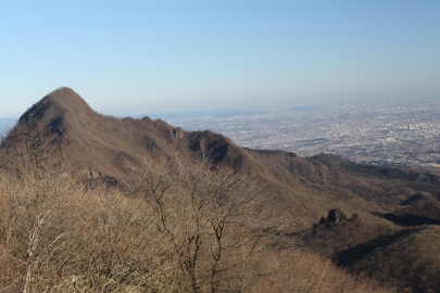
The hike: At the bus stop, look for the red shrine torii which marks the entrance to the trail. If you took the bus from Lake Haruna, you’ll need to backtrack about 50 meters to see it on the left side of route 33. If coming from Ikaho hot spring, then walk along the road away from the direction you came. Go through the series of shrine gates and follow the well-worn path through a forest of bamboo grass and deciduous trees for about 20 minutes until reaching a junction marked with yet another red torii. After climbing a small set of steps, the path takes a 90-degree turn to the right, but you’ll want to head left here, up the incredibly steep rock formations imbedded with rusty metal ladders and chains. This is the route to the summit of Mt. Souma, and it’s anything but gentle. Follow the tape marks up, over, and around the collection of boulders for about half an hour before reaching the summit, marked by a shrine building and Buddhist statues. The views to the east are outstanding, with the buildings of downtown Shinjuku visible on a clear day. You can also see most of the peaks of the Kanto region laid out before you (Mt. Tanzawa, Kumotori, Myogi, Fuji, Kobushi, Kinpu, Yatsugatake, The Minami Alps, Tateshina, and Asama just to name a few). After taking in the views, retrace your steps back to the junction and continue along the ridge towards Surusu-toge (スルス峠) and Haruna shrine (榛名神社). The trail drops to a saddle where you’ll have two options. You can either take the unmarked trail directly ahead, which sticks to the ridge, or you can veer to the right and follow the real path which bypasses the hills. The ridge course offers better views, but both paths meet up a little further on, so take your pick. After this, your next landmark is an roofed-shelter with open walls, which makes a good place to take a break. Just beyond this, you’ll find a trail breaking off the main ridge towards the right. This is the way off the mountain, but continue to the left for now until reaching the base of Surusu Rock. Here you’ll find a side trail on your left with a sign in Japanese reading “スルス岩行人洞3分”. Follow this path for 3 minutes and you’ll find a small cave lined with Buddhist statues and Chinese characters carved into the rock. After some quick photos, retrace your steps to the junction, turn left, and continue on the main trail for about 50 meters or so. Here you’ll find an unmarked trail on your left that leads steeply up to the rock formations. The path banks hard to the right until ending at the base of a metal ladder. Climb the ladder and you’ll find yourself on top of Surusu Rock. Be careful not to slip here, because the fall will likely kill you. The views towards Haruna-Fuji are stellar, and it’s a good place to contemplate life for a while (as long as you don’t suffer from vertigo) When you’ve had your fill, simply retrace your steps back to the unmarked junction. If you’re still fit and it’s early in the day, you can continue along the ridge for another 4-1/2 km or so to the lake. The route is relatively flat and will cross two hard-surfaced roads before climbing up to Mt. Tenmoku (天目山) and Mt. Himuro (氷室山) before ending at the main road at Tenjin-toge (天神峠). From here, turn right on the road and follow it for 10 minutes to Lake Haruna. You could also take a trail from the Tenjin down to Haruna Shrine, where you can catch a bus back to Lake Haruna or out to Takasaki. You’ll need to allocate around 4 hours from Surusu Rock to Tenji-toge. If you’re short on time, then retrace your steps to the junction between the Surusu Rock and the rest shelter and follow the spur trail as it descends to a vast meadow. From here you can walk out to route 33 and turn left to reach the lake, or right to return back to Yaseone-toge. The trail meets route 33 at an interesting area with a series of grooves cut into the asphalt. Wait for a car to head west and you’ll hear a song resembling Eensy Weensy Spider played out on the musical road.
When to go: This hike can be done year round, but you’ll need some 6-point crampons if hiking in January or February. Winter offers the best chance to see the smog-free skyscrapers of Tokyo, as well as clear views of Japan’s highest peak.
Access: The trailhead is a 6km walk along route 33 from the lake. If you’re staying at the lake, then you can catch a local bus bound for Ikaho Bus Terminal (伊香保バスターミナル) and get off at Yaseone-toge (ヤセオネ峠). If you’re coming from Tokyo, then take a train to Shibukawa (渋川), and transfer to a bus bound for either Ikaho hot spring (伊香保温泉) or Ikaho-Harunaguchi (伊香保榛名口) and get off at Ikaho Bus Terminal. From here, you can catch a bus bound for Haruna-ko Onsen Yuusuge (榛名湖温泉ゆうすげ), which stops at Yaseon-toge. The buses are poorly-timed, so double-check both schedules before you set off, or consider breaking up the trip by staying at the hot spring. Click here for the bus from Shibukawa, and here for the bus that runs between Lake Haruna and Ikaho hot spring.
Map: Click here
Live web cam: Click here
Level of difficulty: 4 out of 5 (elevation change ~300 meters)
Distance: 4km (2 to 3 hours)


