Posted tagged ‘nagano’

Mt. Jonen (常念岳)

March 3, 2008

This blog post was written back in 2008. For the latest information about this hike (including color photos and maps), please consider purchasing my guidebook to the Japan Alps. 

Mt. Jonen is a wonderful alpine peak located just across the valley from Hotaka mountain range and Kamikochi. Sunrise and sunset are magical.

Mt. Jonen

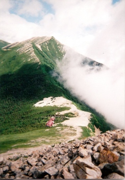
The hike: From the parking lot, walk 4 km on a heavily damaged forest road until reaching the trailhead at Hiedaira (ヒエ平). The road was completely washed out in flooding a few years ago, and if they’ve re-opened it then you can save 8km of easy round-trip hiking. The trail starts off quite flat, following the Ichinosawa (一ノ沢) river upstream to its source. You’ll cross a few tributaries coming off the right side before the real climb begins. It should take about 3 or 3-1/2 hours of hiking along the river before reaching the final steep climb to the ridge line. You’ll know you’ve reached the point when the trail crosses a tributary and starts switching back quite rapidly. Make sure you fill your water bottle at the stream. It should take about an hour of steep climbing before reaching the ridge. Ther’ll be a massive hut greeting you, with the trail to the top of Mt. Jonen branching off to the left. The hut is called Jonengoya (常念小屋) and it’s a good place for a snack break. There’s a descent sized campground here, as well as some toilets. The views toward Mt. Yari and Hotaka are stunning. From the hut, the trail zigzags for about an hour before reaching the summit. The views are incredible if the weather is clear. For some reason, the fog seems to come in very quickly on this shy peak. There are 2 trails branching off from the top, but head back to the hut unless you’d like to traverse onward to Kamikochi. You can either head back down the way you came, stay at the hut, or continue on the ridge line to either Mt. Tsubakuro or Mt. Yari. The extensive network of ridge trails make for an interesting couple of days exploring the beauty of the Kita Alps.

When to go: This hike is popular from Golden Week to early November. Although not impossible, a winter hike requires experience and equipment, but neighboring Mt. Tsubakuro (燕岳) is popular for winter climbing, so a ridge traverse is quite feasible.

Access: While there are a number of approaches to this peak (including from Kamikochi), the hike described here is only accessible by car or taxi, and the forest road may still be closed to vehicular traffic. The nearest station is Toyoshina (豊科駅), on the JR Ooito Line (大糸線) conecting Matsumoto to Hakuba stations. The forest road to the trailhead at Hiedaira (ヒエ平) was closed at the time of writing, which means you’ve got an extra 4km of hiking from the parking lot to the trailhead, so get an early start.

Level of difficulty: 4 out of 5 (elevation change ~1500m)

Mt. Houou (鳳凰山)

February 23, 2008

This blog post was written back in 2008. For the latest information about this hike (including color photos and maps), please consider purchasing my guidebook to the Japan Alps. 

Mt. Houou is one of the most beautiful yet most overlooked of the Minami Alps peaks. The rock formations are stunning, and the views out to Mt. Fuji are breathtaking to say the least.

The top of Mt. Kannon

The hike: First of all, this is almost impossible to do as a day hike unless you get a really, really early start, so plan on camping/staying at a hut along the way. From the trailhead, follow the signs to Yashajintouge (夜叉神峠). It should take around 45 minutes to hike up there. The views are great if the weather is good. There’s a hut and campground here, but don’t quit hiking quite so early. There’s a 3-way junction here, so hang a left toward Yakushi-dake (薬師岳). Most Japanese maps list the peak as 6.5 hours away, but if you’re in good shape and carrying light, you can do it in a little as 4 hours. Luckily, there are 2 huts along the way in case you got a late start or are a slow hiker. The first hut you’ll come to is MinamiOmuro-goya (南御室小屋). There’s a campground and water source here. If you continue another 90 minutes or so you’ll reach Yakushidake-goya (薬師岳小屋), just below the peak. This is a fantastic place to stay if you’d like to catch the sunrise. If you’ve made really good time and aren’t too tired, then why not continue another hour or so to Houou-goya (鳳凰小屋). This is where I stayed, but I approached from Hirogawara instead of Yashajintouge. No matter where you end up staying, you’re in for a treat of a sunrise in the morning. Mt. Houou has 3 main peaks – Yakushi, Kannon, and Jizou, all named after Shinto Gods. The highest peak is Kannon (観音岳), while the obelisk shaped Jizou (地蔵岳) is the symbol of the mountain, appearing in most photographs. If you stayed at Yakushi hut, then climb up to the top of Yakushi, ignoring the trail coming in from the right side. The ridge is pretty easy to walk on, and the limestone rock formations look a lot like snow. Mt. Kannon is the highest point. Admire the incredible view of Mt. Fuji directly in front of you, and the panorama of the Minami Alps directly behind. Continue for another hour or so (again, ignore the trail coming off the right) until reaching Jizou, where a choice has to be made. You could go right and exit the mountain in about 4-1/2 to 5 hours, or you could take a left and follow the ridge toward Mt. Kai Koma-ga-dake, which makes for a good traverse. If you head this way, then there’s an escape route off to the left in about an hour or so. This place is called Hakuhoutouge (白鳳峠). Going left here will take you to Hirogawara in about 3 hours or so. There are plenty of buses from Hirogawara back to Kofu.

When to go: If you’re relying on public transport, then do this hike between late April and November. If you’ve got your own car, then you can attempt this hike in the winter (with the proper equipment of course). Mt. Houou doesn’t get as much snow as neighboring Kita-dake, so it should be approachable in March depending on the amount of snowfall. Double check to make sure the road Yashajintouge is open before you drive all the way there.

Access: From Kofu station, take a bus bound for Hirogawara (the trailhead for the Kita-dake hike), but instead of going all the way there, get off at Yashajintouge (夜叉神峠). I think the first bus from Kofu is 9:30am but don’t quote me on that. If you’ve taken a night bus from Osaka or Tokyo, then double check the bus schedule when arriving at Kofu. Click here for bus information in Japanese. If you descend to Hirogawara, then double check the bus schedule, because the buses are limited in number outside of the peak July/August hiking season (the road is closed to regular cars, so it’s impossible to hitchhike).

Level of difficulty: 4 out of 5 (elevation change 1450m)

Mt. Kashimayari (鹿島槍ヶ岳)

February 21, 2008

Mt. Kashimayari is arguably one of the toughest day hikes around, and the hike described here is a shorter (and more scenic?) route than the Ogisawa (扇沢) approach.

the ridge to Kashimayari

The hike: The trailhead is at the end of a long, dirt, forest road that is, unfortunately, closed to vehicular traffic. That means you’ve got a 4km warm-up at the beginning of the day. The forest road follows a beautiful river, and you should reach the end in about an hour or so, depending on your pace. You know you’ve reached the end because there’s a giant concrete dam staring right at you! This dam is so big that a tunnel has been built to let hikers through to the other side. When I did this hike, it looked like they were preparing to build some kind of pedestrian bridge across the river, but if they haven’t then just use the tunnel. The trail wastes no time in gaining altitude, so fill your water bottles at the dam before setting off. The trail climbs up, up, and up some more. It’s not too difficult at first, thanks to the abundance of small log ladders built into the mountainside. After about 2-1/2 or 3 hours of climbing, you come to a flat spot known as the Takachihodai (高千穂台). This is a great place for a snack, as you’ve got the huge peak of Kashimayari rising directly in front of you. It’s difficult to believe that you’ll be sitting on the top in several hours. After adequate rest, head up the mountain some more. Depending on when you go, you’ll probably run into your first batches of snow in the next area. The trail definitely gets rockier and steeper, but if the weather is good you should have no trouble finding your way. The ridge line will come closer and closer, and eventually you’ll have to traverse to the right in order to hit the ridge. Everything is marked with paint and arrows, but be very careful if it’s raining or foggy. Once you reach the ridge, the trail splits. Left will take you to the top of Jii-ga-take in about an hour, but you’ll want to go right for about 30 minutes until reaching Tsumetaike Hut (冷池山荘). This is a good place to stay if you want to turn this into a 2-day hike. Otherwise, fill up on water and prepare to climb some more. It’ll probably take about 1-1/2 to 2 hours to reach the summit from the hut, as you’ve got a lot of up and down. If the weather is good the views will be phenomenal. If not, then race as quickly as you can so you can come back and rest at the hut! Kashimayari has 2 twin peaks, and the first one you come to, nanhou (南峰) is the higher of the two. The views are stunning to say the least. Mt. Tateyama and Mt. Tsurugi tower to the north, as Mt. Goyru and Shirouma flow gracefully to the east. Look westward, and you can just about count every peak in the Kita Alps. Mt. Fuji? Yep, it’s visible too (on a clear day, that is). Once you pat yourself on the back and pinch your to see if it’s a dream (and take some photos), head back to civilization the same way you came. Or, turn this into a multi-day trek by heading toward Mt. Goryu or the other way to Mt. Harinoki.

When to go: This hike can be done from late April to early November, but the earlier you go, the more snow you’ll encounter. I did this hike in early June, just before the rainy season, and you can see how much snow there still was!

Access: To do the hike described here, you really need your own car (or lots of money to hire a taxi). The trailhead is accessible on the road that goes past Jiigatake Ski Resort (爺が岳スキー場). If you can make it to Oomachi Hot Spring (大町温泉)by bus from Shinano-Omachi Station (信濃大町駅), then you can take a taxi from there or try your luck hitching. Because of the length and difficulty of the hike, you need to camp at the trailhead in order to make it off the mountain before dark!

Level of difficulty: 5 out of 5 (elevation change: ~1600m).

Mt. Takazuma (高妻山)

February 10, 2008

Mt. Takazuma, the tallest peak in the Togakushi (戸隠) range, offers amazing views of Mt. Myoko and the Northern Alps. It’s also one of the only peaks in Japan where cattle can be seen grazing in the foothills.

summit of Mt. Takazuma

The hike:
From the bus stop, walk past the campground and through the cow pasture. The trail follows a small mountain stream and then climbs steeply up to the mountain ridge, where you will find an emergency hut in fairly good condition. It should take about 1-1/2 to 2 hours to reach this hut. From there, turn right and head toward Mt. Gojizo (五地蔵岳). The pyramid-shaped peak of Takazuma will come into view on your left. Follow the trail for about 40 minutes until you reach 八丁ダルミ。There is a lot of up and down before reaching this point. Takazuma will be directly in front of you, and it’s a steep, relentless climb for about an hour, but you’ll be rewarded with outstanding views. Bring a lunch and your camera. The top is very rocky but there are lots of places to sit and enjoy the scenery before going back the way you came. The entire hike should take between 6 and 8 hours.

When to go: I went in May and there was still lots of snow, so bring an ice axe and crampons. All of the snow usually melts by late June, and the fall colors are also beautiful. The first snow usually comes in early November.

Access: Take a Togakushi bound bus from Nagano station and get off at Togokushikyampujo (戸隠キャンプ場)The bus takes about an hour and the first one leaves Nagano at 7:00AM. (Nicely timed for the night buses from Osaka and Tokyo) Click here for the bus schedule.

Map: Click here

Level of difficulty: 4 out of 5 (elevation change: 1183m)

This slideshow requires JavaScript.