The “rock garden” is one of the most popular hikes in the Kobe area, and is renowned for wild board sightings, as well as incredible views of Osaka and Kobe cities.

Special note: It’s quite easy to get lost on this hike, due to the confusing signpost and plethora of side trails that lead to nowhere. My best advice to you is to stay on the main ridge as much as possible, follow the other hikers, and use your instinct.
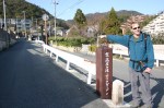
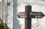
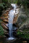
The hike: Go out the north exit (北出口) of Ashiya-gawa station, cut through the small concrete plaza directly in front of you and continue climbing straight ahead. Follow the road towards the mountains, keeping the river on your right. Across the river there’s a beautiful Frank Lloyd Wright designed building sitting on the hill. Built in 1924, it’s one of a handful of original Wright buildings still remaining in Japan, and the only one in the Kansai area. After about 5 minutes, you’ll cross a bridge and see a sign in blue letters reading “高座の滝/ロックガーデン with a red arrow point towards the right. Follow this road for a short bit until reaching a fork in the road and a wooden sign with the same Chinese characters as before. This one has a 左 on top, which is the character for “left”. Take the upper road on the left that climbs up and not the flat road on the right. Another 100 meters or so, you’ll see a road going straight with a yellow sign in black letters reading この先行き止まり/Uターンできません。Strangely, there is are no signs telling you where to go, but turn left here and do not go straight. After 10 meters you’ll see a road going straight but keep towards the right, following the overgrown hedges that curve around on the right side. A little further ahead you’ll see a brown sign reading 高座の滝. Continue on the road you’re on and shortly you’ll enter the forest. The trailhead starts at the very end of the road. Don’t cross the metal bridge on your left, but continue straight past a tea shop selling food and drinks. Kouza (高座) waterfall, just behind the teahouse, is considered to be one of the 100 most beautiful waterfalls in Japan. Cross the small rock bridge in front of the waterfall and you’ll immedately start climbing up some steep switchbacks. You’re now entering the ‘rock garden’, a series of large sandstone formations that are suffering from a massive bout of erosion and overuse. After about 50 meters you’ll see a small clearing on your right with a large concrete dam. This is the hangout of the wild boar, known in Japanese as Inoshishi. Sightings are apparently quite common, but in the half a dozen times I’ve done this hike I’ve only managed to see 1 of the elusive creatures. The trail continues straight ahead and is very easy to follow due to all of the scuff marks. There’s an area with metal chains at one point, but it’s not too difficult. While climbing, don’t forget to look behind you and admire the stellar view of Kobe city. The path meanders through the rock formations for about 15 minutes until reaching the bottom of a large electrical tower. Turn right here and follow the ridge, ignoring the spur trails that branch off down the mountain. As long as you continue ascending and follow the most worn path you should be ok. Occasionally you’ll see a signpost pointing you towards Kazafukiiwa (風吹岩), and you’ll pass under another electrical pylon before reaching the summit. On the summit you’ll find (surprise, surprise), yet another electrical tower! If you’re not sterile before the completion of this hike then consider yourself lucky. Drop your pack and admire the incredible views that are only slightly marred by the power lines. If you want to continue on to Mt. Rokko, then take the trail on the other side of the summit. Otherwise, to complete the loop, pass under the electrical pylon and descend to a saddle. Follow the flat trail for a short distance until reaching a trail junction. Turn right when you see the signpost reading 金鳥山保久良神社を経て阪急岡本JR岡本駅。You’ll pass under another electrical tower before descending to a saddle and a 3-way junction. Turn left here, and you’ll start descending through an area of bamboo grass and steep steps built into the hillside. This area was recently clearcut, revealing mouth-watering panoramic views of Kobe below. If you’re lucky you can also catch glimpses of Akashi bridge and Awaji island on your right. Continue descending and eventually you’ll end up back in the city. There aren’t very many sign posts in the lower section of the hike, and I’ve ended up at 3 entire different locations on 3 separate occasions! Wherever you do end up, just head downhill and ask someone how to get to Okamoto station. The entire hike should take around 3 hours or so, which is perfect as an afternoon hike.
When to go: This hike can easily be done year round, but you should avoid the place during periods or snowy or icy weather, as the sandstone scramble can be potentially deadly if you slip on any ice.
Access: From Hankyu Umeda station, take a Limited Express train on the Kobe line bound for Shinkaichi (新開地) and change to a local train at either Nishinomiya-Kitaguchi or Shukugawa stations. Take a local train on the same line to Ashiya-gawa (芦屋川) station, which is one stop from Shukugawa. On the return, you can take a Hankyu train on the same line from Okamoto (岡本)station, which is only one stop from Ashiya-gawa. The price is 270 yen for a one-way ticket.
Level of difficulty: 2 out of 5 (elevation change ~400m)