Posted tagged ‘Suzuka’

Mt. Fujiwara (藤原岳)

March 1, 2014

Mt. Fujiwara is a rotund, boulder-dotted peak on the eastern cusp of the Suzuka mountains in northern Mie Prefecture. The rolling, grass-lined plains, unique alpine flora, and unobstructed panoramic views make it a popular year-round destination for serious outdoorsy Nagoyaites.

fujiwara1

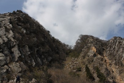
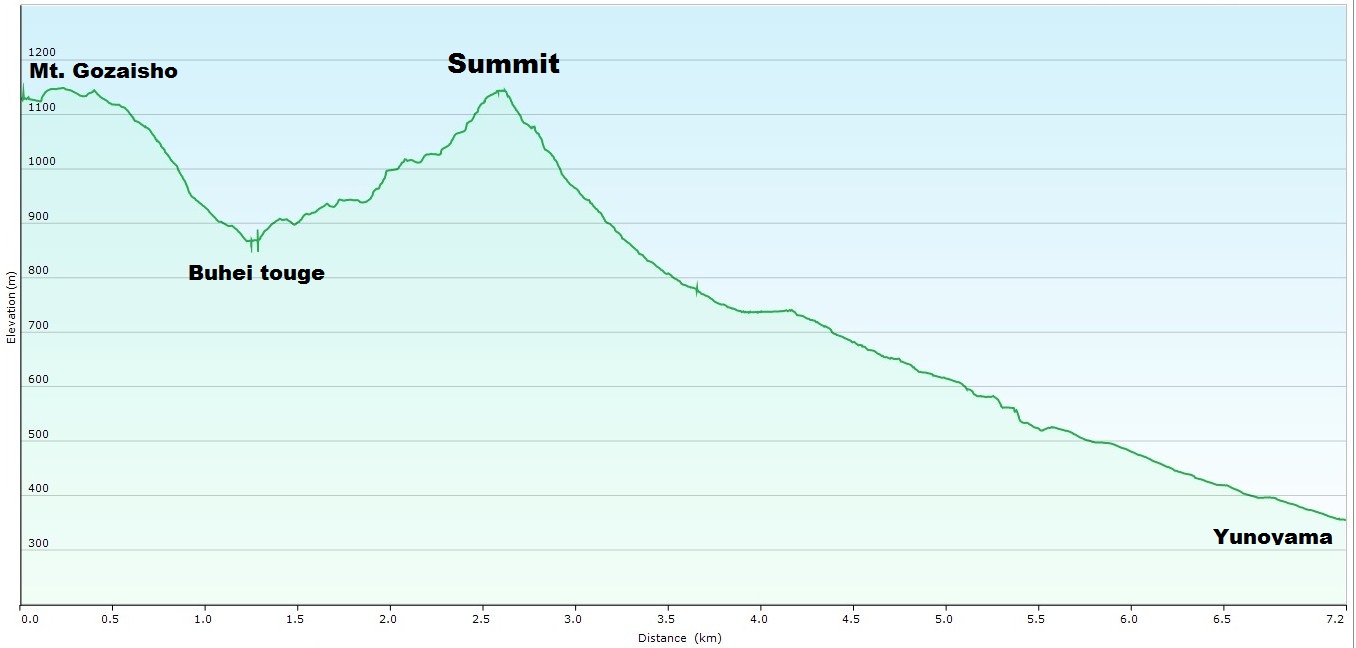
The hike: When you exit Nishifujiwara station turn left and follow the paved road until it meets up with route 614. Cross over the small stream and take your second left (ignore the small street just after the creek). If you reach the elementary school then you’ve gone too far. After you turn, follow the road to the terminus and you’ll find a rest house with some restrooms and a parking lot most likely full of cars and hikers. The trail starts to the left of the building. Go under the shrine gate and head into the forest. You’ll soon pass by a shrine on your left and the real climb will begin. The route doesn’t waste any time gaining altitude, and the first third of the mountain is through a rather boring cedar forest. The path, like most big climbs in Japan, is divided into 10 stagepoints (known in Japanese as gōme). After reaching a fence, turn right following the arrow sign and you’ll soon reach a small rocky area known as the 2nd stagepoint (二合目). Take a quick break here if you need to, because the trail does anything but let up. Just past this the trail will veer towards the right, passing through an area with a metal handrail on the right side. There are a couple of nice beech trees in this area, and you can start to get a glimpse of the valley below in the gaps between the trees. Next it’s back into the cedar forest, past the 3rd stagepoint (三合目) and about twenty minutes further on you’ll reach a small plateau at stagepoint #4 (四合目). Luckily you’ll enter a beautiful area of deciduous trees and the contours will let up a bit. Enjoy this while you can as there’s still a lot of climbing left ahead. After a couple of switchbacks the course will veer left, following a ravine past the 5th stagepoint (五合目) before diving back into a cedar forest on the right. Here the angle steepens once again, and you’re faced with a sweat-inducing slog past the 6th (六合目) and 7th (七合目) stagepoints before reaching the crest of the ridge at the 8th stagepoint (八合目). This is a great place for a break because there is still more climbing yet to come. From here you’ll rid yourself of those pesky cedar trees for the remainder of the ascent. Turn left from the 8th stagepoint and you’ll soon see a junction on your right. This is an alternative way off the mountain that is currently (as of March 2014) closed to hikers. There was a lot of damage in a recent landslide and there’s no telling when the trail will be repaired. If it is open, then it’s an alternative way off the mountain and the path will loop back to Nishifujiwara station. Anyway, continue up the long switchbacks past the 9th stagepoint (九合目) and up a little further for about 20 more minutes until you break out of the forest and reach the summit plateau. You’ll find the mountain hut here nestled against a buffered hillside. It should have taken anywhere from 2-1/2 to 3 hours of tough climbing to reach this point, so reward yourself with a nice lunch or refreshing bottle of water that you should have packed with you.  The summit of Mt. Fujiwara is still about 20 minutes away, so turn left and descend away from the hut, following the sign for tenbōdai (展望台) and over two small rises before reaching the base of the final climb towards the tall point. In the green season there are two paths to choose from, but in winter you can pretty much kickstep your own path up the broad, bald knob, but be careful of avalanches, as they do sometimes occur in this area. The summit itself does not have a signpost marking the summit. Instead there’s a sign reading 展望台, so rest assured you are on the high point. After admiring the panoramic views, retrace your steps back to the hut, where a decision will have to be made. If you continue on the trail behind the hut for another half hour, you can reach a rock formation called Tengu-iwa (天狗岩). If the weather is good and you’ve still got energy I recommend the 1-hour round-trip jaunt, as it enters a beautiful grassy plateau with plenty of wildflowers and far-reaching views. After returning to the hut, simply retrace your steps all the way down the mountain, or consider staying the night in the hut to enjoy the stars and the sunset/sunrise (but bring plenty of water, as the hut has none). All in all it makes for a great alternative to the busier area Gozaisho to the west.

When to go: This hike can be done year round, but you’ll need some 6-point crampons or snowshoes if hiking in January or February. The route is popular with hikers year round, and there’s a free emergency hut near the summit that is basically a floor with no supplies. Bring your own gear and plenty of water if you want to stay here (in winter it’s possible to melt snow). Spring and summer are famous for wildflowers while autumn brings the fall colors and immense crowds.

Access: This hike is best accessed from Nagoya, but if you get an early start or have your own transport then it’s possible to do as a day hike from Osaka. From Kintetsu Nagoya station, take an express train on the Kintetsu line bound for Yokkaichi and get off at Kintetsu-Tomida (近鉄富田) station. From here, change to a train on the Sangi Railway (三岐鉄道) bound for Nishifujiwara (西藤原) and get off at Nishifujiwara. Trains are infrequent, so make sure you check the train schedule before departing Nagoya. It takes about 90 minutes including connection times. From Osaka you’ll need to change trains 3 times and it’ll take around 3-1/2 hours to reach Nishifujiwara.

Map: Click here

Live web cam: Click here

Level of difficulty: 3 out of 5 (elevation change ~1000 meters)

Total round-trip distance: 9km (5 to 7 hours)

This slideshow requires JavaScript.

Mt. Kama-ga-take (鎌ヶ岳)

May 14, 2013

Mt. Kama is one of the hidden jewels of the Suzuka mountain range in eastern Mie Prefecture. The spear-like peak is a thrilling rock scramble with outstanding panoramic views of Ise bay and the rest of the mountains of Mie and Shiga Prefectures.

kama1

Note: If you don’t fancy taking the gondola, then there are several hiking trails to choose from. The most popular route is the Nakamichi (中道), but you’ll need to walk up the paved road for about an hour before reaching the trailhead. The Uramichi (裏道) route starts just past the gondola entrance and it’s a pleasant (and less crowded) climb. The summit of Mt. Gozaisho is an eyesore, with a ski resort, restaurants, and lots of concrete. It’s better to spend your energy getting towards Mt. Kama, which is why I recommend the gondola. In addition, there are outstanding views of Mt. Kama from the gondola: look out the left side of the carriage at the pyramidal peak on the ride up.

The hike: When exiting the gondola, head upstairs and enjoy the views from Fujimi-daira. On an exceptionally clear day, you can see the top of Mt. Fuji sticking up from behind the mountains of Aichi Prefecture. From here, take the concrete steps leading off the lookout point. The path will wrap around and pass by a restaurant (and the chairlift entrance). Climb the ski field just to the right of the chairlift for about 10 minutes and you’ll reach the high point of Mt. Gozaisho. From here, head left on the paved road, following the signs to Buhei-touge (武平峠).  After several minutes you’ll see a signposted path on the right side of the paved path with a warning sign in Japanese telling people it is dangerous (危険). The first part of the route is on slippery sandstone with a couple of low branches hanging across the path (watch your head please). After that, the route drops steeply through an area of large rocks and boulders. At times it feels as if you are traversing the Houou ridge of the Minami Alps with all of the sand stone present. It should take about 30 to 45 minutes to reach Buhei-touge, where you’ll want to take a break before starting the big climb. There are paths dropping off the ridge to both the left and right. The left path will take you back down to Yunoyama onsen, while the right path drops into Shiga Prefecture. The trail to the summit of Mt. Kama is straight ahead, and it’s a no-nonsense ascent of 300 vertical meters through more sandstone and large boulders. It’ll take about an hour to reach the summit, where you’ll have jaw-dropping panoramic views. The final 50 meters to the peak is tricky, with slippery rock and poor footholds. You’ll probably find yourself scrambling on all fours. However, there is a chain here to help you up the pebbly trail. You’ll know you’re just below the summit when you reach a blue signpost that says Kamagatake (Universal). Turn left here for the steep scurry. From the top, there’s a path that drops down on the left, but ignore this and continue on the ridge, past a rusty shrine and to a rock clearing. Don’t be tempted to keep traversing on the knife-edge ridge. The real path drops down on your left. It’s a steep 10-minute descent to Dake-touge (岳峠), where you’ll find a path on your left marked Nagaishidani (長石谷). Take this trail as it descends through a beautiful rocky, dry riverbed. The path can be difficult to pick up, so look for the red paint marks on the rocks and the red tape on the trees. As long as you stay close to the bed you’ll be fine. The gully will eventually turn into a stream with running water, which will grow larger the further you descend. The route crosses this river about a dozen times. The crossings aren’t well-marked, but a good rule of thumb is to stick to whichever side of the river is widest. After about an hour a tributary will come in from the left, and you can find a large waterfall here. There is a signpost on the path (on the right bank of the river) that says Inuhoshiootaki (犬星大滝). If you want to see the waterfall, then cross the stream on your left and you’ll find it about 50 meters up the tributary. It makes a wonderful place for a break. Retrace your steps to the trail and continue downstream. The waterfalls grow in size a bit from this point and the river crossings become a bit trickier, so take your time and make sure to look for the paint marks. There are also a couple of waste-deep pools that look great for a dip (as long as the leeches aren’t out). You’re next big landmark will (unfortunately) be a big concrete dam. You know you’re getting close when the cedar trees start showing up. When you reach the dam, head to the left and take the path that drops very steeply towards the bottom of the dam. This path will meet up with another path (this is the path that drops directly from the summit) and the route will drop back past a couple of more concrete dams before reaching a flat area where you’ll need to cross the river. From here it’s a short walk to the paved road, Turn right and follow the road for about 45 minutes to the bus stop just below the gondola. If it’s a weekend then you can try your luck hitching. Otherwise, wait for the bus that’ll take you back to Yunoyama station.

When to go: This hike can be done from late March to early December. May is the best time for flowers. Avoid the peak from June to August, as the Suzuka mountains are covered with blood-sucking leeches. Winter is for experts only.

Access:  Although it’s very far from Osaka, it can be done as a day trip if you’re prepared for a 5-hour round trip train ride. From Kintetsu-Namba station, take a Limited Express train bound for Nagoya and get off at Yokkaichi station, where you can transfer to the Yunoyama line. Some trains don’t stop at Yokkaichi, so you’ll need to transfer to a different Limited Express train at Tsu. From Yokkaichi, take the Yunoyama line and get off at Yunoyama Onsen station. From the station, take a bus to Yunoyama onsen. The buses are infrequent, so if you’ve got some people with you, it’ll be faster to share a taxi to the ropeway (a one-way taxi is about 1300 yen). From Nagoya, there are some direct trains to Yunoyama onsen, and there are direct buses as well, which will drop you off just below the gondola entrance. Click here for the Nagoya-Yunoyama bus schedule and here for the bus from Yunoyama station to the gondola.

Level of difficulty: 4 out of 5 (elevation change ~500 meters)

Distance: 7.5km (3-1/2 to 7 hours, depending on whether you use the gondola or not)

Vertical elevation chart:

 kama - vertical

This slideshow requires JavaScript.