Posted tagged ‘hiking’

Mt Higashi Azuma (東吾妻山)

September 7, 2025

Extra Details:

Access: For those without a car, consider using the Jododaira Sky Access service. For hikers, the 5.5 hour plan will allow you just enough time to complete the hike. Please book at least a day before your departure (either online here or in person at the Tourist Information Center just outside of the west exit Shinkansen gates of Fukushima station). You’ll either be in a shared taxi or microbus depending on how many other hikers book the service. The meeting point for the tour is in front of the Tourist Information Center on the 2nd floor of JR Fukushima station (near the west exit entrance gate of the Shinkansen). The 5.5 tour costs 8000 yen per person (4000 for children ages 7 – 12, free for kids 6 and under) and includes round trip transport to Jododaira. It really is worth it. If you took a taxi by yourself from the station to Jododaira without using this service it would easily cost you 10,000 one way.

Hike timing if using the taxi/bus service: If you are using the Jododaira Sky Access service, you MUST finish your hike and arrive back at Jododaira by 3pm. This means that you should leave the summit of Mt Higashi Azuma no later than noon if you are doing the loop via Keibadaira. If you are behind schedule, skip the loop and head back the way you came to Jododaira. Additionally, check your timing when you reach the paved road at the end of the loop. If it is after 2pm then consider walking on the road back to Jododaira as it’ll be faster (the 2.5km distance on the road should take you about 30 minutes).

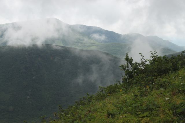
The hike: The route is easy to follow but there isn’t much in the way of English signage, so make sure you follow the directions in the video above very carefully and memorize the key kanji for the hike. The most important kanji is for Higashi Azuma (東吾妻) but it might also be good to remember Kamanuma (鎌沼), Keibadaira (景馬平), Torikodaira (鳥子平), and Jōdodaira (浄土平). The trail between the summit and the skyline road via Keibadaira is not well traveled or maintained. Be sure to use a digital map app to make sure you don’t get lost.

When to go: Aim to go on a dry day and not the day after heavy rain as I did. The trail becomes a river and a muddy bog after heavy rain and it’ll be slow going. If you want to see the rhododendron, then aim to go from late May to early June. Summer is a great time to go, as the summit is usually 10 degrees cooler than Fukushima city. Weekdays will be less crowded than weekends, as Jōdodaira is a bit of a tourist trap with hordes of car tourists stopping by to climb Azuma ko-fuji. There’s a restaurant and souvenir shop and usually a food truck or two next to the restaurant. Jododaira is open from early-to-mid April to mid-November and the autumn colors usually peak between late September and mid-October.

Tozan Book Review

August 22, 2025

Did you know that a dollar bill weighs about 100 grams? And if you have a stack of 700 one-dollar bills in your hand that they would still weigh less than Tozan, a monstrous new self-published book about Willie’s quest to climb the 100 mountains of Japan?  

William Banff, better known by his pen name Willie Walks, is the first known Australian to have climbed the Nihon Hyakumeizan, or One Hundred Mountains of Japan, and this book is a travelogue of sorts, documenting his journey in agonizing detail. 

Clocking in at well north of 100,000 words, the 546-page behemoth may appear daunting at first, but not as formidable as Willie’s own challenge to climb the Hundred Peaks. The book starts with an informative introduction and then presents each mountain chronologically rather than geographically, so readers can follow along in “real time” on Willie’s quest.

Willie is not one to mince words, and with colorful language and creative Willie-isms scattered throughout the book, it is one hell of a wagon ride. You know it’s going to be an epic tale when the first word of the narrative is “CHRIST!”

If there’s any way to describe Willie’s writing style, if would have to be: Bill Bryson on speed. Willie will make you laugh, shake your head in disbelief, and head under the blankets for cover, all in one sentence! His adjective-laden style takes a bit getting used to at first, but once you dive in there’s no turning back, and his attention to detail, his natural gift to help “paint the scene” if you will, is second to none. For instance, in chapter 57:

“The sky wheels above me, the sun adheres to its set course, and the cloud and rain drift at the mercy of the winds. The ground is an ever-mutating treadmill of surfaces beneath my boots. Rock, earth, mud, moss. It’s introspection on steroids. A meandering meditation. All the façades held in place by the demands and expectations of life down on the flats long fallen away. I can hear myself again. Who have I been all these years? Who will I be when I walk out of these mountains?” 

Despite the War-and-Peace size of the volume, readers can rest assured that it is definitely a page turner, and straight into the first chapter on Ibuki-yama, there’s already a sense of being drawn into the narrative, eager to discover the next hiccup and anecdote along the way. These are the kinds of stories that grandpa might tell you on his death bed, full of life and vigor of days long gone. 

Each mountain is broken into its own chapter, so it can be taken in small doses, similar to someone climbing the Hundred Mountains themselves, so if you read just one chapter a day you can finish in a little over three months, which is a lot faster than actually trying to climb the Hundred Mountains yourself. 

Every chapter is headed with a sketch of the mountain climbed, crafted by Willie’s own hand. In addition, he has also hand-drawn a map for each region, which is by no means an easy task. The only thing that could better complement the book would be to perhaps fill some of the dead space on some of the chapters with a black and white photograph or two, so readers could further visualize the scenery at play. To compensate for this, Willie has put photos of each mountain on his website.

What the book could look like with some photos included

So as we head toward the holiday season and cooler weather, consider picking up a copy of all 788 grams of Tozan at your online bookseller named after a South American river. You just might not be the same and you don’t have to be a mountaineer, a Japanologist, or even someone interested in the outdoors to enjoy it. Click here for more details.

Numazu Alps Full Traverse (沼津アルプス全山縦走)

April 20, 2025

Extra Details:

Access: Baraki station (原木駅) is on the Sunzu Line of the Izu Hakone Railway. It’s just a 16-minute train ride from Mishima Station (三島駅). If coming from Tokyo, you’ll find it faster to take the Shinkansen to Mishima and transfer there. From Numazu Station (沼津駅) at the end of the hike, it’s a 5-minute train ride back to Mishima Station.

The hike: While the hike is relatively well-marked, the route is long, with plenty of fixed ropes, so make sure you start early to avoid running out of daylight. However, there are plenty of escape routes along the way so you can bail early if you don’t have to stamina or time to do the full hike. Bring plenty of water and snacks as there aren’t any places to replenish supplies along the way.

When to go: The views of Mt Fuji are pleasant, so aim to go when the weather is good and Mt Fuji is not hidden in cloud. April and May are the best times, as well as October and November. Summer is also possible but avoid the extreme heat in July and August.

Mt Migita (右田ヶ岳)

January 24, 2025

Extra Information:

The trail is pretty well-marked, but the 33 Kannon statues on the slopes of Mt Sekisen (石船山) are hard to find.

When to go: This can be done year round except for the days when snow falls in Hofu city. Be careful of heatstroke in the summer and Japanese hornets in September and October.

Access: While you can walk from Hofu station (about 90 minutes to the trailhead), a taxi will save you a lot of time and hassle. The bus from Tsukahara at the end of the hike is infrequent. You can use this website to search. Just type Tsukahara and select for Hofu station and it will tell you when the next bus will arrive.

Kasugai Sanzan (春日井三山)

September 27, 2023

Additional Details:

Make sure you check the bus schedule in advance. Meitetsu’s bus website is a bit convoluted but you can search for the bus by plugging in starting from 高蔵寺駅北口 and going to 植物園. It’s only 7km to the trailhead so if you have a couple of people then a taxi shouldn’t be too costly.

I recommend not only downloading the digital map from YAMAP, but also printing this simple paper map that you can use to cross reference against the numbered signposts on the approach to Miroku.

Hyakumeizan Book Review

February 3, 2023

Mention the Nihon Hyakumeizan to any Japanese hiker and you’ll likely receive an earful of personal anecdotes of successful ascents, breathtaking sunrises, and elusive wildlife. Indeed, it seems as if all mountaineers have their sights set on scaling every single peak on the venerable list. But what exactly is the Nihon Hyakumeizan? How were they chosen, and what makes these mountains noteworthy? Martin Hood answers these questions and much more in his fantastic book One Hundred Mountains of Japan

Originally published in mid-1960s, Nihon Hyakumeizan won the esteemed Yomiuri Prize for Literature in the Biography/Criticism category, and helped to spawn a hiking boom that has grown unabated. What was initially created as a personal list of 100 notable mountains that author Kyūya Fukada had climbed over his 40-year hiking tenure, soon became a de facto list of ‘must-climbs’, akin to Colorado’s fourteeners or Europe’s 4000-meter alpine summits. Even Crown Prince Naruhito attempted to finish the Hyakumeizan before becoming Emperor. Go to any bookstore nationwide and you’ll find numerous hiking guidebooks in Japanese for all of the mountains featured in Fukada’s book. 

Nihon Hyakumeizan is a collection of stand-alone essays that Fukada penned for the mountaineering magazine Yama to Kōgen. In 1964, all of the essays were compiled into a best-selling book that is still in-print to this day. Despite its enormous influence and appeal, the book had never been translated into another language until Martin Hood took upon the challenge to transform Fukada’s rich prose into English. Upon finishing the translation, publishers were reluctant to release the volume due to classification problems. This is addressed in a blog post on One Hundred Mountains:

“One Hundred Mountains (of Japan) is devilishly hard to categorise. Not unlike the geological mélange of Kita-dake, that mountain for philosophers, it blends together bits of this and bobs of that —  a soupçon of travelogue here, fragments of literature and history there, all mixed up, but with masterly assurance, into a zany matrix of zuihitsu-style essay writing.” 

Eventually University of Hawaii Press saw the historical significance of the work and published it under the genre of ‘Japan/Nature/History/Literature’. Hood’s translation is unprecedented in that it is the first English-language translation of any book on Japanese mountaineering.  

Fukada’s original Japanese text is so laden with obscure historical references that most Japanese people have a hard time understanding it. Hood overcomes this hurdle by providing a comprehensive glossary for every single historical figure mentioned in the text. That, accompanied by a 40-page introduction, makes the book accessible to anyone with even a cursory knowledge of Japanese history and culture. The introduction itself is a stand-alone work, in what must surely be the first comprehensive English-language anthology of modern mountaineering in Japan. The books starts with a detailed biography of Fukada’s life, followed by a thoroughly researched exploration of the influence of Japan’s most important mountaineering figures on the shaping of Nihon Hyakumeizan. Indeed, this introduction gives context to the book, providing a much-needed rooting of the text in the history of modern Japan.  

The book is required reading for anyone with even a passing interest in Japan’s mountains, for Hood’s translation shows not only how the mountains received their historical nomenclature, but also gives clues about the evolution of the landscape. Fukada’s text was written just as Japan was embarking on a massive post-war modernization, much to the detriment of the natural surroundings. Fukada captures these fleeting moments in the days before cedar plantations and forestry-roads-to-nowhere forever disfigured the scenery. The text also describes the mountains as if they were living creatures, something that is eloquently captured in the chapter on Mt. Tomuraushi, a mountain in Hokkaido:

“Kaun-dake is the rocky peak that marks one end of this broad-packed ridge. We scrambled onto its cramped summit and paused for a moment. At that moment, the clouds cleared to reveal mountains all around us under a flawless blue sky. But it was Tomuraushi, above all, that drew my gaze to the menacing bulk of his rocky shoulders.”

Canadian photographer Peter Skov provides the stunning cover photo book (paperback version only, so be aware if purchasing the hardcover). Additionally, the book features a full-color photo insert from Hood’s film photography collection showcasing some of the Hyakumeizan peaks as well as one additional photo from Skov.

The only drawback to Hood’s translation is the lack of maps. Indeed, Fukada’s original book has a map in each chapter, as well as a full illustration of Japan that shows the location of all of the peaks. Readers of the translation are well-advised to have a paper map or digital app at their ready when exploring the descriptions of the mountains. Perhaps this can be remedied in future editions of One Hundred Mountains of Japan.

Will this translation finally convince foreign publishers that English-language books about Japan’s mountains do have a willing audience? Only time will tell.

You can purchase the book here on Amazon or on the publisher’s website.

Kuroi Castle Ruins (黒井城跡)

January 23, 2023

Extra Tips:

There are two main paths up the mountain. I recommend ascending via the Nadaraka Course (なだらかコース) and descending via the Kyūzaka Course (急坂コース) to make a nice loop hike. At the trailhead, you’ll notice a small parking lot, toilet, and a long set of stairs on your right. These stairs is where you will complete the loop, so instead of heading to these steps, head straight and follow the signs for なだらかコース. On the descent, retrace your steps down from the summit (ignore the path on your left that reads 多田方面) go back through the animal gate and down the switchbacks to the flat area in front of the red gate. Instead of heading back to the red gate, hang a hard left here and follow the signs for the 急坂コース. It’s a steep but easy-to-follow track that leads straight down the mountain and to that set of concrete stairs at the end.

History:

The castle was built by the Akai Clan in the 14th century but is best known for having be seiged by Akechi Mitsuhide, who is best-known as the man who betrayed and killed Oda Nobunaga. The castle became abandoned just before the start of the Edo Era and all that remains now are the castle wall foundations and a spectacular panoramic view.

Digital Map (Avenza App): Click here

Mt Ryūō (竜王岳)

January 14, 2023

Extra Tips:

A longer path to Ōhara is to take the main ridge from the junction to Mt Amagatake (天ヶ岳) which is one of the 10 peaks of Ōhara. Please note that it is easy to get lost, especially on the far side of the peak, so make sure you have the digital and paper maps. Here is my trip report so you can get an idea of what to expect.

Another good way to end your hike is by having a soak at the baths at Kurama Onsen. There are two bath houses, and I personally recommend the outdoor bath. However, please note that the hot spring is currently closed due to a COVID infection among staff, so double check their website before heading there.

Digital Map in English (Avenza App): Click here

Kumano Kodo Guidebook Review

July 16, 2019

It’s the winter of 2007, and I’m hiking along an isolated track called the Kogumotori-goe in southern Wakayama Prefecture with my newlywed wife Kanako. The faint, poorly-marked trail leads up to a viewpoint flanked by a large weather-beaten jizō statue. Armed with a Japanese magazine about the Kumano Kodō, we scan the kanji text and barebones descriptions to find that we’ve reached the Hyakken-gura tenbōdai. We pause here, admiring the splendid views while poring over the limited knowledge in our less-than-ideal information source.

Had we been armed with Cicerone’s latest guide to the Kumano Kodo, Kanako and I would have been in much better hands and definitely would have taken a bus to Yunomine Onsen instead of opting for the extra 6km uphill walk on a paved roadway at dusk.

The Kumano Kodō has come a long way since our fateful walk a dozen years ago. Since becoming a World Heritage site in 2004, Wakayama Prefecture has invested an immense amount of money into both promoting and maintaining the Nakahechi route, adopting the ‘if you build it he will come‘ philosophy that would make Kevin Costner proud. Indeed, the Field of Kumano Dreams has not only brought in the tourists, but has put the Kumano Kodō on the world stage by teaming up with the Camino de Santaigo to form a dual pilgrim program and creating an English-language support network connecting visitors to the many inns and facilities along the way. This has resulted in a 40-fold increase in overseas visitors compared to just a decade ago.

But I really don’t need to tell you all that. One quick net search will reveal a wealth of information about the riches of Wakayama Prefecture, and it’s one reason why I haven’t devoted much of my server space to the Kumano Kodō on this website. Indeed, with the diligent work of their bi-lingual employees, the Kumano Tourism Bureau has created an on-line guide like no other available in Japan, all for free of charge. There’s enough on that website alone to help you plan and walk the Kumano Kodō. So why buy a guidebook at all?

The answer lies within the 230 pages that Kat Davis has devoted to her informative guidebook, a well-researched gem of a publication filled with nearly a hundred spendid full-color photographs. Rather than clicking through web pages and trying to collate all of the information into a notebook, you have everything you need in this guide, and you won’t need a wi-fi connection to enjoy it.

The guide features full descriptions of the Nakahechi and Kohechi routes, each of them 4-day treks through an interesting part of the Kii Peninsula. Part nature walk, part history lesson, the 6 routes outlined in the guidebook offer visitors a chance to experience an ancient pilgrimage route steeped in history. It is the informative explanations of the various Buddhist statues, teahouse ruins, and hidden shrines that sets this guide apart from others, as the author adds context to the historical markers along the way, many of which do not have English explanations.

Additionally, the full-color maps give just the right amount of detail without being too overbearing, and the elevation profiles for each route, marked in a myriad of symbols, provide vital distance and elevation gains that are essential for trip planning. While at first the symbols can be a bit difficult to decipher, a quick study of the map legend at the front of the book, along with a bit of practical use will surely have walkers praising their inclusion. She even goes as far as to include the location of vending machines on the maps, something that even I have come to appreciate during my exploration of Japan’s hidden backroads. The only thing missing from the maps themselves are kanji characters, which Kat makes up for by providing the kanji within each hike description, which will surely be helpful for those unable to read the language.

Besides the concise descriptions of the walks themselves, the book contains recommendation for places to stay and eat for each hike, along with information about soothing hot spring baths and local specialties. Vegetarian hikers will want to bookmark the Japanese phrases on page 45 of the introduction so they can use at the various inns and restaurants they encounter along the way. Indeed, the guide seems to have all of the bases covered, offering a handy arsenal of practical and up-to-date information that both first-time visitors and long-term residents can appreciate.

If there is one thing I would like to see added to the guidebook, it would be at least one walk on the Okugakemichi, which is by far the most beautiful section of the Kumano Kodo. The tough route connects Kumano Hongu Taisha with Yoshino in Nara Prefecture 100km to the north, and features towering old-growth forests, precipitous cliffs, and spectacular views from some of the highest mountains in western Japan. Regrettably, one section of the route is still off-limits to women, and much of the terrain is hardly tourist-friendly, requiring a head for heights and route-finding ability. Still, the final section between Tamaki Shrine and Hongu via Mt. Godaison would be the icing on the cake for this Kumano Kodo guidebook. Perhaps the publisher will allow a slight expansion of routes for the second edition of the guide, if the book proves to be popular. Do your part now to ensure that such valuable resources continue to remain in print by purchasing this excellent guidebook.


Mt. Shokanbetsu (暑寒別岳)

July 5, 2016

Mt. Shokanbetsu is one of Hokkaido’s best kept secrets. The long approach turns off all but the most hardcore of hikers, and the alpine scenery and panoramic views make the effort worthwhile.

IMG_3194

Note: There are three different routes up the mountain. The most popular route is called the Uryū route (雨竜ルート) which traverses through the Uryū marshlands and over Mt. Minami Shokanbetsu before reaching the summit. It’s a one-way 12km hike that isn’t too steep but really long. There’s a great description here if you’re interested. The second most popular route is called the Shokan route (署寒ルート) and it starts from a forest road that is well-signposted in Mashike town (you’ll see a signpost at the 7-11 along the main road through town). This route is an 11km hike to the top that follows the northern ridge of the peak. The third route (and the one described here) is called the Hashibetsu route (箸別ルート) and it traverses the northeastern ridge through an area teeming with alpine wildflowers. It’s the shortest trail up the mountain (9km one-way) and offers a taste of alpine scenery without the crowds of the marshlands to the south. There is a free emergency hut each trailhead, which means you could easily traverse up and over the mountain, staying at one of the huts at either end. This is a long but relatively easy way to experience the beauty that the Shokanbetsu range has to offer.

The hike: From the parking lot, take the trail that starts next to the emergency hut. There’s a box here where you can register your hiking intentions. The path immediately dives into a beautiful pristine forest alive with insects and the sounds of nature. Bring some insect repellent if you don’t want to get eaten alive by mosquitos. Also, keep an eye out for bears, as the animals like to use the hiking trails to travel. The first few kilometers of the hike are relatively flat, and the route, like most big hikes in Japan, is divided into 10 stage points which can help you with the pacing. It should take about 30 minutes or so to reach the first stage point (一合目), which will likely have you gazing in disbelief that the hiking has only just begun. After an hour or so you should reach the 3rd stage point (三合目), where the real climb begins. It’s a gentle climb at first, which become steeper the higher you go. Once you reach the 5th stage point (五合目) the views will start to open up a bit and the path will become much rockier. In rainy weather the route will turn into a creek, so make sure you bring some rain protection or a change of clothes to help keep you dry. At the 7th stage point (七合目), the trail will finally break out of the treeline and will traverse through an area of splendid wildflowers. The views towards the Uryū marshlands will also open up, and you can see Mt. Minami Shokanbetsu off in the distance, a deep valley between your present position and the mountain. In good weather the path is easy to pick up, but in fog make sure you stick to the paint marks on the rocks. Just past the 8th stage point (八合目) you’ll top out on your first summit, and the path will drop steeply to a saddle at the 9th stage point before climbing a long peak directly in front of you. At the top of this long rise you’ll reach a junction where the Shokan route meets up with this route. The two paths will merge into one, so turn left at this junction and follow the signs to the summit (署寒別岳山頂). It should take about 15 minutes from this point to reach the high point, which is marked by several signposts. If the weather is good you’ll be staring down at the Sea of Japan directly below you, and behind you the Daisetsuzan mountain will soar off in the distance. From here a decision will have to be made. If you came by car, simply retrace your steps all the way back to the trailhead. If you want to do the full traverse, then follow the signs to Mt. Minami Shokanbetsu (南署寒別岳). It’s a long drop to a broad saddle, followed by a long climb to the summit. From there, follow the signs to Uryū numa (雨竜沼), which will take several more hours of long but easy hiking to reach. Allow around 10 hours to complete the full traverse, and bring enough gear and food to overnight at the emergency hut at the trailhead. If you need a place to stay in Mashike, I recommend the guesthouse Bochibochi Ikouka Mashikekan (ぼちぼちいこか増毛館), run by a friendly family from Osaka. It costs 4900 yen with two meals and the traditional structure dates from 1933. The owner can give you climbing advice and also has a free map of the mountain.

When to go: This hike can be done from July to early October, when most of the snow is gone. The peak is popular with cross-country skiers in late spring. A winter ascent is for experts only, as the deep snow drifts and unforgiving weather cause a few fatalities every year.

Access: You really do need your own transport to complete this hike. From Mashike town, take route 231 out of town to the north. Just before crossing Hashibetsu Overbridge (箸別跨線橋) turn right (you’ll see an old folks home on your right). There’s no signpost here so it’s really easy to miss. If you reach Hashibetsu station then you’ve gone too far. As soon as you turn right you’ll see a signpost pointing to the right for the Hashibetsu route of Shokanbetsu (署寒別岳箸別ルート). Turn right here and follow the signs to the trailhead. The road will climb via a few switchbacks before reaching the terminus, which is marked by a free emergency hut and small parking lot. You could take a taxi there from Mashike station if you don’t have your own transport, traversing down the other side of the mountain through Uryū marshlands (雨竜沼湿原), where you could possibly hitch a ride from there. Be warned that it’s a grueling 25km hike, so get an early start if you want to do the full traverse.

Level of difficulty: 4 out of 5 (elevation change ~1000m)

Total round-trip distance: 18km (6 to 8 hours)

This slideshow requires JavaScript.