Posted tagged ‘Hokkaido hikes’

Mt. Mashu (摩周岳)

February 6, 2012

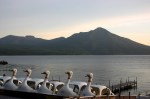
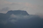
Perched on the shores of a stellar volcanic lake, Mt. Mashu offers a chance to experience a taste of the Hokkaido backcountry without a huge climb to get there. It may also offer your best opportunity to spot the elusive Japanese brown bear.

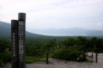
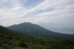
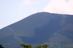
The hike: The trail starts at the end of the massive parking lot, just beyond the toilets. Look for the sign that says 摩周岳登山口. Don’t forget to write your details in the trail register located just below the signpost. The trail starts with a long descent to a saddle, with outstanding views of Lake Mashu on your left, framed nicely in the foreground by some photogenic wildflowers. From here, the trail starts a series of gentle climbs, followed by some long, gradual descents. There are signposts spaced evenly throughout the entire hike showing distances, which you can used to judge your pace. The trail really doesn’t fully pop out of the treeline until around the halfway point. When you see the signpost that reads “摩周岳3.3km”, the trail will start to open up a bit. Be careful on this next section, because at the crest of the next hill is where I saw two bears, right in the middle of the trail! Luckily it was on the return trip, so I could spot them from a very long way away. Fortunately, they escaped into the forest when they heard my bell, so please make sure you carry one. If you don’t have one, then the hostel owner will probably let you borrow his. Your next landmark will be a trail junction for Mt. Nishibetsu (西別岳). This is a good place for a break, because the steepest part of the hike now awaits. Ignore this junction and continue to the left for the final 1.9km push to the summit. The trail will start to become quite steep as you climb towards the crater rim. Keep climbing, and after an hour or so you’ll find yourself sitting on top of the bald, rocky top of Mt. Mashu. The highest point on the ridge is directly in front of you, but the ridge is much too treacherous to proceed any further. You’ll have an awe-inspiring panoramic view of the entire lake, as well as nearby Mt. Nishibetsu. If visibility is really good, you should also be able to see Mt. Shari and the peaks of Shiretoko National Park. After admiring the views, retrace your steps all the way back to the trailhead, and drop by the visitor’s center to eat some ice cream or warm noodles. It should take anywhere from 4 to 6 hours to complete the hike, depending on how many breaks you take. Bring plenty of water in the summer, because there are no water sources on the entire trail.

When to go: This hike can be done from late April to mid-October, when the buses to Lake Mashu are running. If going early or late in the season, be prepared for a lot of snow and perhaps some hungry bears. Be careful of horseflies if hiking in August and whatever you do, don’t forget your bear bell!

Access: From Mashu station (摩周駅), take a bus bound for Mashu Daiichi Tenboudai (摩周湖第1展望台) and get off at the last stop. Please note that between July 16th and October 10th you’ll need to buy a 1-day bus pass just to get on the bus. It’ll set you back 1500 yen, even if you’re only going up to the lake and back. It’s a good value if you plan on seeing other sites, but if not, then consider staying at Mashu Youth Hostel and just hitching up and back from the lake like I did. Catching a ride should be easy, since there’s only 1 road to the top. Another option would be just to take the regular non-tourist bus between April 23rd and July 15th. Click here for the bus schedule.

Live web cam: Click here

Level of difficulty: 2 out of 5 (elevation change 320m)

Distance: 14.4km (4 to 6 hours)

This slideshow requires JavaScript.

Mt. Tarumae (樽前山)

October 28, 2009

Mt. Tarumae is an active volcano located on the shores of Lake Shikotsu in Western Hokkaido. In addition to the outstanding views of the lake below, the mountain offers a rare chance to view an unstable lava dome.

tarumae1

The hike: There’s a toilet and a small hut at the trailhead, but no water to speak of, so make sure you fill up before leaving Lake Shikotsu. The trail immediately starts gaining altitude, but the going is made easier with an endless array of wooden steps. You’ll reach a small clearing after 10 minutes or so, where the views will start to open up. You’ll see Lake Shikotsu directly behind you and Mt. Fuppushi rising steeply on your right. Directly in front of you lies the conical peak of Mt. Tarumae. The trail cuts a beeline directly across the eastern flank of the volcano, similar to what occurs on the trail up Mt. Asama in Nagano Prefecture. The trail is well-maintained and is suffering a bit from overuse, so it’s almost impossible to get lost. You’ll reach the crater rim in about a half an hour or so, where you’ll find a junction. Turn right for Higashi-dake (東岳), the high point of the crater. The views towards the lake below are spectacular, and on a clear day you can see Mt. Yotei rising gracefully in the distance. If you’ve got time, then you can circumnavigate the entire crater rim in about 2 hours or so. Just follow the trail around towards Nishi-dake (西岳). Whatever you do, don’t enter the caldera to get a look at the gigantic smoldering lava dome, as the gases will likely kill you. The lava dome has been growing steadily since 1909 and is now taller than the crater itself. This is an extremely active volcano with a long history of powerful eruptions and is currently under 24 hour surveillance by the Japan Meteorological Agency. When you’ve seen enough then you can simply retrace your steps back to the parking lot. If you’re looking for a more challenging hike away from the crowds, then you can consider climbing neighboring Mt. Fuppushi. There’s a trail to the summit on the other side of the parking lot. It should take about 3 to 4 hours to reach the top, where the views are outstanding. Make sure you bring a bear bell and/or bear repellent as the col between Tarumae and Fuppushi is a popular hangout for brown bears.

When to go: This hike can be done from mid April to late November, when most of the snow is gone. A mid-winter ascent is also possible for those with winter mountaineering experience and equipment, but you’ve got a much longer approach since the road to the trailhead will be closed.

Access: The start of the hike is only accessible by private transport. You can get as far as Shikotsu-kohan by bus, from where you can hire a taxi for the 3000 yen journey to the trailhead. Click here for the bus schedule from Sapporo to Lake Shikotsu. The number for the taxi company is 0123-25-2111. Just tell them you want to go to Tarumae-tozanguchi. You can also try your luck hitching by walking out to the main road just above the parking lot at Shikotsu-kohan.

Map: Click here

Live web cam: Click here

Level of difficulty: 1 out of 5 (elevation change 363m).

Mt. Tomuraushi (トムラウシ)

March 9, 2009

Home of the endangered Japanese pika, Mt. Tomuraushi is a wonderful rocky peak located at roughly the halfway point on the Daisetsuzan trekking route. The scenery and views will certainly make you believe you’ve left Japan.

tomuraushi1

The hike: First of all, I would like to thank Julian for this hike description, as I climbed this peak while doing the full Asahi-dake to Tokachi-dake traverse. From the bus stop, head to the end of the road and the trailhead. After about 5 minutes of hiking, you’ll cross a forest road, where you’ll find the lovely Higashi Daisetsu hut, which looks like a great place to stay. Click here for the website in Japanese. Continue hiking on the trail for about 90 minutes or so, until reaching a trail junction marked 温泉コース分岐 (Onsen kousu bunki). This is where foot traffic will increase signficantly, as the trail to the right leads down to a parking lot. Most people with cars just drive up here rather than hiking from the hot spring, so if you’ve got your own wheels you might consider doing the same (especially if doing this hike as a day trip, which I don’t recommend). Turn left at the junction for a moderate climb up a well-worn path. If it’s raining then the path will become a nasty mixture of water and mud, so bring gaiters if you’ve got them. After about 45 minutes or so, you’ll reach an unmarked junction, which is where the old path joins the new. The old path is closed, so stay towards the left and climb through an area of thick bamboo grass. This grass is trimmed during the summer hiking season, but may not be maintained out of season, so exercise caution. The next hour or so is relatively gentle until dropping steeply to a the ‘Robin’ stream (こまどり沢). Be sure to boil and filter any water from the stream, because it could be contaminated with the echinococcus parasite. Cross the stream and stay on the right bank (following the paint marks on the rocks if the weather is bad). If hiking before August then you’ll have to cross a rather large snowfield before reaching 前トム平 (Mae-tomu-dai), a great place for a break. The trail will start to become quite rocky now, passing through areas of wildflowers before reaching a small pond at トムラウシ公園 (Tomuraushi-koen). Be sure to follow the paint marks, since it’s easy to get lost if the cloud is in. The scenery is spectacular, and you’ll reach a junction in about an hour or so. To the left there is a small campsite with a water source (again, be sure to boil) but no toilet. Turn right for the steep, 20-minute climb to the summit. It should have taken anywhere from 6 to 8 hours to reach the summit, so be sure to bring plenty of supplies and consider breaking this up into a 2-day hike. You can either retrace your steps to the campsite, or consider traversing over to Hisago-numa hut (ヒサゴ沼小屋), which will take another 2 or 3 hours of ridge hiking. Alternatively, you could consider heading all the way back to Tomuraushi Onsen, but that’d be over 30km of hiking in one day! Click here for some nice photos of the route.

When to go: This hike can only been done in the summer, when the bus to the trailhead is running. If you’ve got your own transport, however, you can go a little earlier or later in the season. Alternatively, the peak is on the main Daisetsuzan trekking route, and can be approached from the north via Chuubetsu-dake. Be prepared for a lot of snow if attempting before July.

Access: From Obihiro (帯広) station, take a local train on the JR Nemuro line and get off at Shintoku (新得) station. You can also take a limited express train, but it’ll cost twice the amount. From Shintoku, take a bus bound for Tomuraushi Onsen (トムラウシ温泉) and get off at the final stop. As of 2011, the bus is by reservation only and runs between July 16th and August 14th. Click here for the schedule.

Level of difficulty: 4 out of 5 (elevation change 1176m)

Mt. Meakan (雌阿寒岳)

January 14, 2009

Mt. Meakan is an active volcano located around 20km southwest of Lake Akan in Central Hokkaido. Its current status as an active volcano offers a unique opportunity to stare into the mouth of a hissing volcanic crater.

meakan1

The hike: From the bus stop, backtrack down the main road for about 100m and you’ll see the hiking trail on your right. The trail starts off in a forested area, where you’ll clamber over exposed tree roots on the heavily traveled path. After about 40 minutes or so, the views will start to open up, and you’ll see the huge, smoldering peak directly in front of you. It looks very close, and indeed it is, but it’ll still take the better part of an hour to reach the crater rim. The vegetation thins out the higher you go, and the summit is not the place you want to be in a thunderstorm, so use common sense if the weather is bad. Once you reach the crater rim, turn left for the short climb to the high point. Marked by a rectangular stone pedestal, the summit offers wonderful views down to Lake Akan, as well as a bird’s eye view of the stinky, hissing, hell-like crater directly below. The conical peak of Akan-fuji towers just to the left of the crater, and on a clear day the peaks of the Hidaka mountains can be seen way off in the distance. From the summit, continue along the rim of the crater towards Onetto (オンネトー). The trail will quickly drop to a saddle at the foot of Akan-fuji. Climb the conical peak if you’ve still got energy and if it’s still relatively early in the day. Otherwise,keep descending on the path towards lake Onetto. You’ll soon enter a forest which becomes quite dense as you approach the lake. Just before reaching the end of the trail, you’ll find a flat, swampy area that looks like a stomping ground for bears, so make sure you have your bear bell with you. The trail ends at a gravel road. Turn right to reach the campground. You could turn left if you want to do the side trip to Yu-no-taki (湯の滝), a hot spring waterfall, but be warned – the free open-air bath has been dismantled in the name of environmental protection, so if you’re expecting a hot bath then you’ll be sorely disappointed. I wouldn’t recommend this side trip as the waterfall isn’t really that big and isn’t gushing out hot water either! Anyway, the campground charges for camping space and the water must be boiled before drinking, so make sure you’ve brought plenty of water with you from Akan-kohan. Walk through the campground and follow the trail that goes around the lake. Lake Onetto is phenomenally beautiful – the emerald green colors put the beaches of Okinawa to shame! About halfway around the lake you’ll find a trail junction on your left. This is the trail back to Meakan-onsen and it’s also an area with a fair number of bears. A late afternoon stroll through here without your bear bell is definitely an accident waiting to happen. It should take about 30 minutes or so to complete the loop back to the hot spring. There are two places to stay at Nonaka-Onsen. The youth hostel is looking a little worse for wear, and was completely booked when I visited, so I opted for the adjacent Kokumin-shukusha, which charges 7000 yen for 2 meals and has one of the best baths in all of Hokkaido. Click here for the website.

Special Note: As of August 2011, the trail to Me-akan is open. If any further volcanic activity becomes apparent, I will update this status. There’s still a lot of steam billowing out of a side vent near Akan-Fuji, so take care if the winds are blowing from across the crater.

When to go: This hike can be done from Golden Week to early October, when most of the snow is gone. The road to the trailhead is open all winter, so those with the right experience, equipment, and their own transport could also attempt this in the winter, but I would be very cautious on days with poor visibility and high winds. The road between Meakan hot spring and Onneto is popular with cross-country skiers and snowshoers.

Access: Please note that the bus from Akan-kohan to the trailhead has been abolished. The only way to get to the trailhead is by car, taxi, or hitching.  From Kushiro (釧路) station, take a bus for Akan-kohan (阿寒湖畔) and get off at the last stop, which is a large bus terminal. Click here for the bus schedule. You can also take a bus from Mashu Station, but there are only 2 buses a day and they only run from July to October. Click here for that schedule.

Live web cam: Click here

Level of difficulty: 4 out of 5 (elevation change 789m).