Last updated: Feb 7, 2025
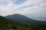
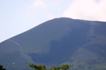
Mt. Himekami is a inverted wedge-shaped peak situated roughly 20km north of Morioka city in Iwate Prefecture. The views of Mt. Iwate and the alpine flora make this area a hit with locals throughout the year.

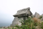
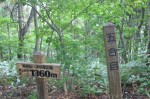
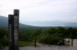
The hike: From the parking lot, head up the trail past the toilet block of the small campground. After around 5 minutes you’ll enter the forest and cross the dirt forest road. This is where the trailhead proper starts and where the taxi driver will drop you off unless you say otherwise. The path is well-trodden and easy to follow. Meander through the cedar forest for a few minutes or so and you’ll come to a large cedar tree and a water source on your right. Please note that as of August 2010 this water is unsafe to drink, and there are signs in Japanese warning hikers not to do so. This is the only water source on the mountain, so make sure you fill up at the parking lot before you start the hike! Anyway, from here the trail parallels the stream, traversing a steep area with lots of wooden steps built to help prevent erosion. Eventually you’ll reach the 5th stagepoint (五合目), a good place to take a break. The path continues its steep ascent with even more steps (reinforced with concrete, no less) to assist in your effort. After 10 minutes of sweaty climbing, the route abruptly turns right, traversing the side of the mountain until reaching the 8th stagepoint (八合目). Be careful of this traverse in the winter/spring if the snow is unstable. From the 8th stagepoint, the best part of the hike awaits, as the alpine flowers will now start appearing in the rock formations around the trail. Although steeper than before, this really is very pleasant hiking, especially due to the lack of boring wooden steps! You’ll still be in the treeline, so it’s difficult to gauge how far you need to go, but don’t give up. In around 20 minutes you’ll reach a junction. Either path will lead you to the summit, but I highly recommend taking the right fork, as there’s a fantastic section of boulder-hopping that awaits. The forest turns into brush pine as the views really start to open up. Mt. Iwate towers over everything else around, and if visibility is good you can even see Mt. Chokai way off in the distance. Mt. Hayachine will be due east as well. Keep hopping over the rocks for about 5 minutes, turning left to reach the summit. Take a break here and admire the spectacular scenery. If you’re hiking in the winter you might want to avoid the right fork and just stay left for the easy zig-zag route to the top. You can take this trail on your way back down if you like as well. All in all, it should take around 90 minutes to reach the summit from where the taxi dropped you off. From the summit, simply retrace your steps back to the parking lot. There’s also another trail called the kowazaka route (こわ坂コース) that’ll also take you back to where you started, but it involves a long walk on a forest road to get you back to the parking lot. There’s also another trail that heads southwest from the summit that leads to the Shironai (城内) trailhead, a longer, less popular approach. I personally haven’t used that route so I unfortunately can’t offer any advice on that approach.
When to go: This hike can be done from April to November without too much trouble or effort. Bring a pair of chain spikes/crampons/snowshoes and watch out for the boulders on the summit if attempting this hike in the winter. Click here to see the beautiful winter scenery.
Access: Please note that there is no public transportation to the trailhead, but you can affordably take a taxi. From Morioka station, take a train on the exotic-sounding Iwate Galaxy Railway (Iwate Ginga Tetsudo in Japanese) bound for Metoki (目時) and get off at Koma (好摩) station. The train takes around 25 minutes. From there, tell the taxi driver to let you off at Ipponsugi Tozan Guchi (Ipponsugi trailhead). The driver will probably try to take you up the forest road to the actual start of the hike, but ask him/her to let you off at the shuushajou (parking lot) because there’s a toilet and water source there. The taxi should cost around 3000 yen. If there’s no taxi waiting at the station, then call 019-683-2311 in Japanese and tell them you are at Koma station and want to go to Himekami san.
Map: Click here
Level of difficulty: 2 out of 5 (elevation change ~600m)